We’re digging in the dirt – thanks again, PRSC

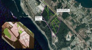
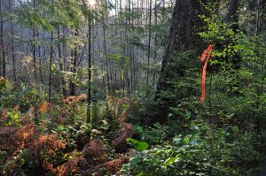
Tearing up the “looped road” on the ALR, 30 July 2019
Remember: you can click on any image to see the full-size version, and click “back” to return
A musical interlude

I’m not very musical by nature, but in my humble opinion Peter Gabriel had “rather a lot to say”.  In particular, I think his “Secret World” performance is a masterpiece.  In one of my least-favourite parts of it, he croons:

we’re digging in the dirt
to find the places we got hurt

I think Mr. Gabriel  was expressing something that most people (not just scientists) know through experience.   There’s no such thing as a perfect anything…but successful humans and organizations strive to learn from mistakes.

Stuff happens

Take me, for example.  Having tried to build an accurate history of “Lot 450”, well, I still get surprised occasionally.
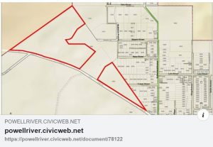
As posted on Facebook, 27 July 2019
It wasn’t the document that surprised me.
But the shape of the land-parcel did.

Consider the image above, which was recently posted on Facebook.  It didn’t make sense to me.  I’ve been studying these exact same land parcels for years…so to me it looked like a big bite had just been taken out of the southeastern corner of the upper parcel.
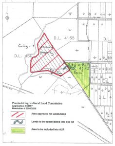
Aha. Here’s the bite. This is page 5 from the ALC Decison of March 26 2010.
I’d looked at this document before, but hadn’t realized that a land SALE was involved.

What is this…Shark Week?

Thus I learned about another land sale by PRSC.  The details are simple enough.  PRSC sold 13.5 acres to Hatch-a-Bird Farm back in 2010.  As part of the deal, land was added to the ALR.

My Facebook informant helpfully reported that the ALR inclusion was a “condition of sale”.

Aha.  Because the sale involved ALR lands, an application was required – and a decision was made.  I’d seen that decision before, but confess that I hadn’t connected-the-dots (or georeferenced the map).

Fundamentally, what this meant for me is that I needed to fix all my  date-stamped maps.  Much cursing and gnashing of teeth ensued.
Oh well.

Hopefully the revised PRSC “land story” is more accurate than it was.

Digging into the books

Elsewhere I’ve written about the desirability of having a “full accounting” of the PRSC experience.   I’m not alone.  Enter Pat Martin, who’s been pestering City Hall with Freedom-of-Information (FOI) Requests since she first appeared as a “Delegation” before the Committee of the Whole in January of 2019.

Pat has achieved some remarkable success.  For the first time we now have  PRSC’s financial books.  Or, more accurately, we have copies of their two sets of books.  Here they are:

PRSC Land Developments Ltd – Financial Statements
PRSC Limited Partnership – Financial Statements

Now if you’re like me, at first glance having two sets of books doesn’t make a whole lot of sense.  Then I thought about it some more.  Perhaps it’s like maintaining separate life-tables for males and females in a wildlife population – there might be sound reasons behind this division that are not easily appreciated by a layperson.  I accept that there might have been some reasons for this division – and I doubt we’ll ever learn what they were.

It doesn’t matter.  There are more interesting things to be found in the financial statements.  I began by calculating some basic statistics as follows:

The first obvious conclusion from this is that PRSC Land Developments Ltd never sold any land.  Indeed this was the much smaller of the two PRSC entities, reporting a total of only $33,668 in “revenue” and $110,363 in “expenses” over 13 reporting periods (the PRSC “fiscal-year” ended on 31 March – and the first and last reporting periods were not “full years”).

PRSC Limited Partnership was the much bigger brother, with close to $9 million in revenue,  $876,203 in expenses…and a whopping $5,948,977 in “costs of sales”.

So taken as a whole, the combined PRSC enterprise showed a net profit of $2,194,480 from 2007 through 2018.  So far so good.

When did PRSC become profitable?
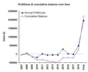
Figure 1: Annual Profit/Loss and Cumulative Balance as reported by the PRSC, 2007-dissolution.
The numbers are combined totals from the PRSC Limited Partnership and PRSC Land Developments Ltd.

Here’s a time-series with two variables.  Specifically, I’ve plotted annual “profit/loss” and a calculated “cumulative balance” against “fiscal year”.

This is quite revealing.  Apart from a small positive “blip” in 2008, PRSC carried a negative balance until its final year of operation in 2018.

I’ll say it again: PRSC only became profitable in its final year of existence, after previously-unsold lands were acquired by the two remaining partners.

I’m still confused by this.
Did money actually change hands in 2018?  Or was the “appraised value” of land used to create the appearance of a “profit” at time of dissolution?

Land sales and profits over time

Now that an “end-of-game” scorecard has been obtained…
How much did PRSC actually earn by selling all those ex-Catalyst “surplus” lands?
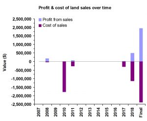
Figure 2: Profits and costs of land sales by PRSC Limited Partnership, 2007-dissolution.
This graphic omits “revenue” reported as “cost recovery” or “forfeited deposits” in 2015 and 2016.
The bottom line is that it cost $5.9 million to sell lands worth $8.6 million.

I explored this question by focusing my attention upon the Limited Partnership and selecting only those fiscal years in which “costs of sales” were reported.

In scientific terms, I “constrained the sample”.  Thus I ignored revenues from “cost recovery” (FY2015) or “forfeited deposits” (FY2016).  I don’t know what those mean, and I wanted to compare apples with apples.

There were six years in which PRSC reported “costs of sales”.  The bad news for PRSC shareholders is that these costs were 69% of the gross value of the lands.  In 2010 they lost money (-$20,427) on lands that sold for $1.76 million.  In 2017 they earned only $16,939 from the $330,000 sale of Wildwood Hill (this represents the only instance in which it’s possible to tie revenues to a particular land sale).

I’m frankly dumbfounded by figures such as these – but maybe there’s a reasonable explanation.  Unfortunately the financial statements provide no details about how “costs of sales” were calculated.  The bad news for me is that I’m unaware of any land sold in 2008, but the data suggest there was – so I may be needing to update all my date-stamped maps again when that information becomes available…
aaargh

Filling in the blanks

The financial records unfortunately don’t break down revenues by property.  Period.   The result is that it becomes impossible to ask questions about “good property deals” versus “bad ones”.   Nor is it simple to reconcile financial records with those from other sources.  A few examples will illustrate the difficulties.

We know, for example (from the MLS listing) that the property that became Timberlane Estates sold on 10 March 2009 for $260,000.  This sale doesn’t show up in the FY2009 report for the Limited Partnership, even though their “fiscal-year” ended on 31 March.

The FY2010 report shows that year to have been a relatively good one – with $1.76 million worth of sales.  Approximate dates are known for some of these sales.  Millenium Park sold in 2010 (the Peak announced it on Feb 10th), as did the 32 acre “farm in Cranberry” (the Peak reported that on Jul 21st), and Hatch-a-Bird Farm (Facebook in 2019).

Allowing for some delay in “the paperwork catching up”, I think it’s reasonable to make informed guesses about what must have happened.  Accordingly I pooled the data for FY 2010 & 2011 revenues, looked at the listing and selling prices for the properties that I knew about, and guessed at the ones I didn’t.   The result looks like this:
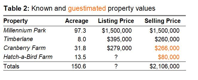
That gets me pretty close to the reported total of $2,106,550 for the two years.  None of it, however, explains the ginormous costs of sale ($2,057,035) or the puny profit that ensued ($49,515).

Will it ever end?

There are numerous other oddities and inconsistencies to be found throughout the PRSC financial records.

There’s a substantial accounting error in the 2018 PRSC Land Developments Ltd statement caused by adding two negative numbers incorrectly.   The value of the PRSC “Land Inventory” goes up in some years – by adding the cost of property taxes paid.  Yes.  You read that correctly.

I note that the PRSC financial statements were audited for only two of the 13 reporting periods (FY2007 and FY2008).   Subsequent statements were unaudited and contain wording like this  – a situation I don’t find comforting at all.
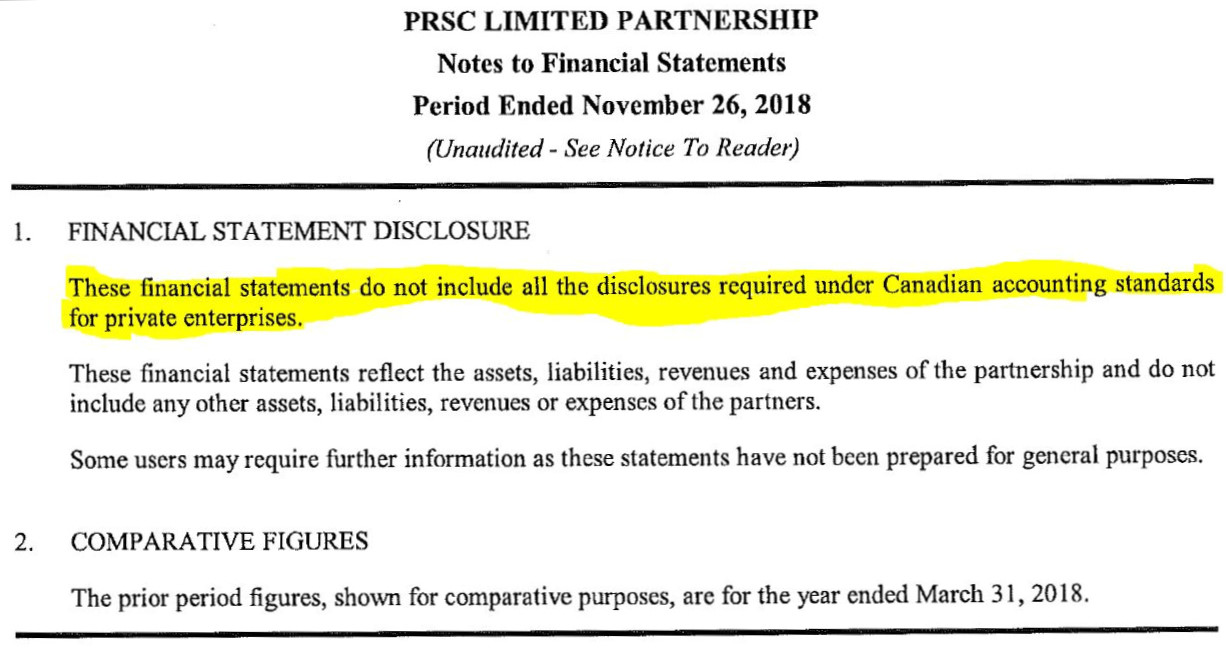
So I think some kind of a retroactive audit is long-overdue…if for no other reason than to save us from doing the same thing over and over again while expecting a different result.

In essence?  Having explored things in some detail, I think the taxpayers of Powell River got hurt.

PRSC was ill-conceived and sloppily managed.  There were promises but no real attempts at “transparency”.   It shouldn’t have taken FOI requests to obtain financial records, it shouldn’t have needed “social media” to learn about land sales in 2010, and it shouldn’t have been possible to build a road on the ALR to service the neighbour’s housing development…especially when the “neighbour” was also a “Founding Director”.

I remain saddened that we collectively seem to want to avoid recognizing the fact that these were mistakes
– and we might learn from them.

Meanwhile, Peter Gabriel is still digging …in my head at least.

House of dark shadows: requiem for the PRSC

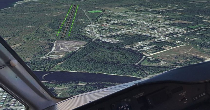
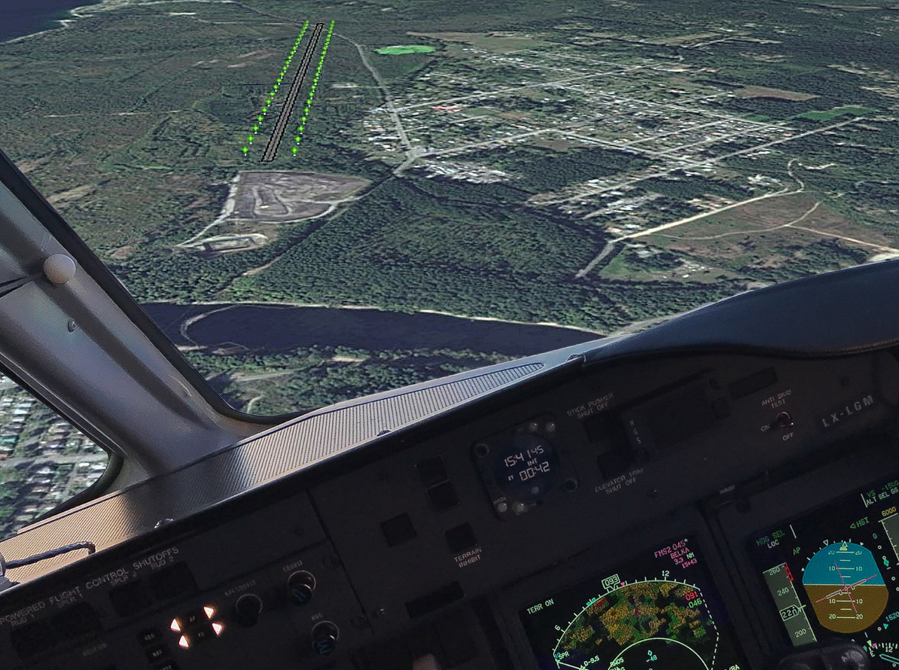
“On finals at YDC”. This is the international airport as envisioned in the 2006 Yrainucep proposal  
The location and dimensions are accurate – I georeferenced a map, created a runway shapefile and uploaded that to Google Earth so I could see it. The planned over-run of Highway 101 at the far end is also accurate. The cockpit-view is of course fake, as is the runway lighting. My too-shallow landing approach would have yielded an “F” grade from my flight instructor.
But we’re talking about the PRSC here. Seen through the lens of history, the “joint venture” was seemingly incapable of recognizing its own “failed-approaches” over time.
Context

When I first built this website to “map things” so I could better understand land and forest ownership issues, I wrote:

  • “There are three major landowners: Catalyst Paper, Island Timberlands, and the PRSC Limited Partnership.
  •  Together these three entities own about 29% of the land contained within city limits, and 64% of the original Lot 450 . 
  • The history of land ownership is convoluted, but these three “big players” are the reason why this website is designed the way it is.”

That was then.  My map-making skills have improved somewhat.  And rather a lot has happened since those first heady “stop-the-cut” days of 2015.  But I didn’t anticipate this:

The PRSC is no more
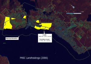
2006 PRSC landholdings
Here are the land parcels transferred from Catalyst to the newly-formed Powell River-Sliammon-Catalyst (PRSC) Limited Partnership in 2006.  Some parcels contain a “foreshore lease” – so some of the lands are submerged.

It’s true.
Quietly and without fanfare, the PRSC Limited Partnership has dissolved itself.  Behind closed doors.  Admittedly there were clues that this was going to happen.

Indeed the Peak reported, way back in April, that the writing was on the wall:

“Tla’amin is proposing that it and the city dissolve PRSC Limited Partnership, a joint venture between the city and Tla’amin’s Tees’kwat Land Holdings, with each entity holding a single share.”

I kept looking for, without success, some “official” notification that this had actually happened.  I couldn’t find it in the Peak or in City Council documents.  And as has happened before, several links to external documents from this website simply “disappeared” overnight.  Panic set in:  my goodness, now I’ll have to redraw my maps and redesign the entire website!   No.  That won’t happen.  Why?  That’s easy.
But I digress.

In the course of looking for other stuff, land title searches revealed that ownership of the Old Golf Course and Gibson’s Beach properties had changed on 14 September (with the golf course going to the Powell River Waterfront Development Corporation and Gibson’s going to Tla’amin Nation).  Exactly as the Peak had reported.

Dissolution of the PRSC, as reported in Neh Motl (November 2018)
As official as it gets…
Click to enlarge

Social media reported on 15 January that “a search of company records indicates that on December 11, 2018 PRSC was dissolved.”  That may be true.  Perhaps one day a kind reader will share that document so I can post it here.

For me, the final piece of the puzzle arrived just a few days ago, when a colleague pointed me to the November issue of Neh Motl, the Tla’amin Nation newsletter.

Sure enough, there it is, on page 15.  The final PRSC meeting occurred three days before land-transfer applications were received by Land Titles.

So.  The PRSC is gone.

My first question is: so what did the PRSC actually do, and when did they do it?  Forgive my scientific training – but that needs a timeline, methinks.  Here goes:

The PRSC Timeline

*  Trust me – you’ll want to see this fullscreen.  Your browser will open a new tab and it’ll look much nicer that it does when confined to the box below.  Hint: You can scroll through it using the arrows, or jump to a particular spot on the timeline.

**  I designed this to be a live dataset – to be easily updated as errors and omissions are found and reported.  Be brutally critical – and send me an email.  My hope is that what remains will stand the test of time.


Whew!  I think that’s enough for one arm’s length limited partnership.  More soon.

Housekeeping matters: more about the ALR

Sino Bright parcel, 9 November 2015
Somewhere on the “Sino Bright parcel”,
9 November 2015
The ALR

Mention the ALR in Powell River and you’ll likely evoke strong reactions – some love it, some see it as an impediment to development, and some see it as yet another great idea mis-managed.

Me?  I’m reminded of Aldo Leopold, who wrote:

There are two spiritual dangers in not owning a farm.  One is the danger of supposing that breakfast comes from the grocery, and the other that heat comes from the furnace.”  

The farm
Madrone Soils Map
Agricultural land capability as mapped by Madrone Environmental Services, with the Sino Bright parcel and proposed ALR exclusion superimposed. Some areas (e.g. the haul road and McGuffie Creek) are not suitable for agriculture at all.
On this map the brownish areas are rated as “poor”, blue-grey areas are rated as “fair”, and dark green and teal-colored areas are “good” (improvable to Class 1 or 2).

To begin: the agricultural potential of the Sino Bright parcel is modest.

Madrone’s 2007 land capability report is thorough and credible.  A portion (40%) of the area contained “good” agricultural soils (i.e., improvable to Class 1 or 2).  The majority (53%) was rated as “fair” or “poor” (improvable to Class 3 or 4).

In short, this is not prime agricultural land.  Especially if you view farming as having to be large-scale, or mechanized, in order to be successful.

That’s nonsense, of course – there are all sorts of ways to successfully farm smaller areas, even in tiny Powell River.

Personally, I suspect that opportunities for mechanized farming were greater on the 112 ha that was excluded from the ALR in 1994 – precisely because it’s flatter.   But I digress. My point is that the Sino Bright parcel is functional agricultural land, for reasons that Aldo Leopold would have fully appreciated – because it’s being used to grow trees.

Well, it’s sort of being used to grow trees.  Here’s where history intervenes, and things get complicated.

Some history
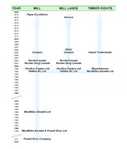
Timber rights on the property were conferred by a sequence of corporate name changes, acquisitions and divestments over time.
In particular, the demise of MacMillan Bloedel Ltd in 1998-99 saw the unusual separation of land ownership and forest ownership.
[UPDATED Sep 2019]
The current landowner (PRSC) acquired the land from Catalyst, who got it from a subdivided MacMillan Bloedel Ltd, descendant of the original Powell River Company of 1911.

However, timber harvest rights have been considered separately since 1998, when MacMillan Bloedel restructured itself.  In this case the flow of timber rights was from MacMillan Bloedel to Weyerhaeuser to Island Timberlands.

For this reason the current (PRSC) or future (Sino Bright) landowner has little control over forests, or the timing and methods of harvesting.  It’s akin to buying a farm without control of the crop.

I recognize that the Land Commission’s mandate is not to evaluate how well landowners have maintained the integrity of agricultural lands or invested in their future potential.   Their job is to a) preserve agricultural land, b) encourage farming on it, and c) encourage local governments to do the same.

The furnace
Exhibit A:  Two sequential Landsat 7 images using 4-5-1 bands.  This band-combination is useful in evaluating vegetation changes over time.  Bottom line?
About 22% of the Sino Bright parcel (and 25% of the standing timber) was logged between the two dates.

Two things caught my eye while exploring this particular land parcel.  Specifically, its agricultural potential has already been degraded.

The first problem stemmed from logging, in this case by MacMillan Bloedel and Weyerhaeuser, in 1999-2000.  The logging itself is not the issue.  I have no problem with thinking about forests as a crop – indeed that’s why we have a “tree-farm license” system in BC.  From my perspective this is a good idea, especially if it encourages the maintenance of forests, forestry workers, and biological diversity.

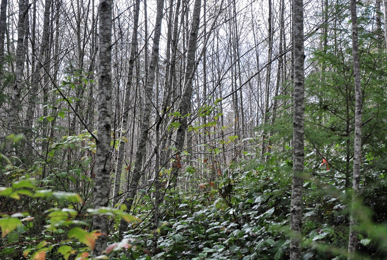
Sadly, however, in this instance (and in many others in the region), clearcutting and removal of wood was followed by…nothing.  The land was neither replanted nor tended with forestry values in mind.

So instead of a healthy young crop of fir, hemlock and cedar, these areas are now overgrown with red alder and blackberries. When asked their opinion of the harvested patches and what they’d advise doing with them, two foresters who walked with me expressed the same opinion: “mow it down and start afresh”.

State of forest regeneration inside one of the areas harvested in 2000. This photo was taken on 31 October 2015. Click to enlarge.
Forest regeneration in one of the areas harvested in 2000. This image was made on 31 October 2015.

Because I’m an ecologist who understands the value of early successional forests, I don’t think I’d go so far.

But their opinion does underscore my point. Some 16 years after harvest, a substantial portion of the area is not what it could have been.

Or to use Aldo’s words…

…the land is not being used to its full potential, providing for breakfast or the furnace.

The language of the original timber License is quite explicit:

“The Licensor acknowledges that the Licensee has the full right and privilege to harvest and remove the timber growing on the lands as of May 31, 1998.  A harvesting plan is to be reasonably agreed to between between the Licensee and the Licensor.”

The agreement further states that upon termination, the lands and roads will be left “in a condition reasonably acceptable to the Licensor” and that

“Once the timber has been harvested in accordance to the agreed upon harvesting plan and removed by the lands by the Licensee, this license and all rights inferred will terminate.  Any remaining timber not harvested by the Licensee at this time will belong to the Licensor.”

One would assume that the terms of the license were fulfilled – i.e., that there was a harvesting plan “reasonably agreed to” by Pacifica Papers (the Licensor in June 1999) and Weyerhaeuser (who acquired the Licensee MacMillan Bloedel Ltd in November of that year) – prior to any trees coming down.

weyerhaeuser
Weyerhaeuser
The future is growing

So I remain puzzled by the subsequent grant of timber rights by Norske Skog Canada to Weyerhaeuser in June of 2005 – with no mention of the fact that the Licensee had already exercised their rights by cutting 1/4 of the standing timber.  I’m puzzled also that Weyerhaeuser, which advertised itself as the “tree-growing company”, had not replanted the land – or seemingly been asked to do so by the Licensor.

Was the “reasonably agreed to” harvesting plan in 1999 just considered to be incomplete in 2005?

As in “sure, my company can mow your lawn…we’ll do the easy bits now, then come back later to finish up… maybe in five years time…or fifteen years…or whenever we feel like it”.
Really?

I suspect we’ll never see details of the agreed-upon harvest plan.  It was likely just an annotated forest cover map, with some notes about road access.  Some might consider that this is old news, and doesn’t really matter.  I would argue that it very much does matter, because it comes down to a question of what the future may hold for a parcel of land that still contains substantial forest values.

Another problem

The second problem was something that at first I thought was the GIS version of a “typo”. What I’d noticed, after comparing Landsat imagery and ALR maps, was something odd.

Clearing of Timberlane Estates in 2010
Exhibit B: This sequence of images shows forest clearing for the Timberlane Estates subdivision between July of 2009 (A) and July of 2010 (B). More land-clearing (this time for installation of the Timberlane athletic track to the north) occurred shortly thereafter (C).
As can be seen on an image from 2011, the semi-circular loop road at the top of Hemlock Street was constructed on the ALR.

Had a paved municipal road really been constructed on the ALR?   Yes.  Could I be certain of when it was constructed?  Yes.  Was there an application related to it, or a decision made about it?  Well, not that I can find.

Housekeeping matter
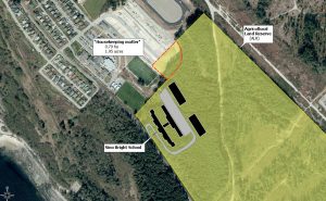
This is the “housekeeping matter” referred to in City planning documents when it was belatedly realized that the road was constructed on the ALR.

Construction of the road amounted to an “effective” ALR exclusion size of about 0.8 ha (1.8 acres).

The Powell River Peak again provides essential context (sadly, many of their online archives have disappeared).

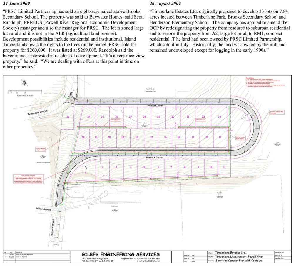
One article described the land sale, and a follow-up story provided more details and a map of the planned subdivision.  From these it’s apparent that the road was part of the design from the very start.

These two Powell River Peak articles provide historical context for the road - but seemingly the ALR was forgotten in the process. Click to enlarge.
Exhibit C: Two Powell River Peak articles provide historical context for the road
– but seemingly the ALR was forgotten about in the planning process.
 part of the ALR...
part of the ALR…

At this point it’s impossible to be certain about why or how this happened.  But it did, and it means that in terms of the subdivision for which 8 acres were sold by the PRSC, about 10 acres were actually used to develop it.

Yes, more nibbling away at the ALR – Powell River style.

It is rather a nice road…but somehow I think Aldo would be unimpressed.

The Yellow Ribbon Project

If you're walking about in Lot 450 and encounter some of these yellow ribbons, you may be wondering what it's all about...
If you’re walking about in Lot 450 and encounter some of these yellow ribbons, you may be wondering what it’s all about…
It seemed like a good idea at the time

Like many wonderful ideas, I can’t take credit for it.

In May of 2015 George Orchiston made a Freedom-of-Information (FOI) request to the Municipality of Powell River.

The intent was to obtain correspondence between the City and Island Timberlands, the Powell River Waterfront Development Corporation (PRWDC), and PRSC.  You can read all 89 pages of the official response to him here.

Shortly after Ellen Gould relayed that document to me, she crucially asked what I thought about the language contained in the timber harvest licences .  This happened while I was trying to map past forest logging from satellite imagery, Ellen was helping to map clearcuts in the field, trying to enlist legal opinion on behalf of the Powell River Forest Coalition.  Between us a crazy notion was born.

Some months later I’d managed to convince two other people of the beautiful irony of trying to save mature fir and cedar by decorating 15 year-old alder trees with yellow ribbons (think Charlie Brown Christmas trees).  We yellow ribboneers had great fun, donations paid for most of the cost of flagging tape, I thought some of the resulting photos were pretty good – and in the end the idea never really took off.

Except that the trees are still standing.  The legal timber harvesting rights of Island Timberlands are now a little clearer, even if the responsibilities of PRSC towards the people of Powell River and Tla’amin are not.  And that, I hope, may provide grounds for more informed discourse about what is possible for those lands.

So, because images can help put things in context, here’s the essential what, where and why behind “The Yellow Ribbon Project”.

Click on any thumbnail to invoke a full-screen slide-show…