We’re digging in the dirt – thanks again, PRSC

Tearing up the “looped road” on the ALR, 30 July 2019
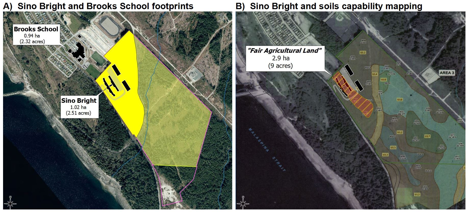
Remember: you can click on any image to see the full-size version, and click “back” to return
A musical interlude

I’m not very musical by nature, but in my humble opinion Peter Gabriel had “rather a lot to say”.  In particular, I think his “Secret World” performance is a masterpiece.  In one of my least-favourite parts of it, he croons:

we’re digging in the dirt
to find the places we got hurt

I think Mr. Gabriel  was expressing something that most people (not just scientists) know through experience.   There’s no such thing as a perfect anything…but successful humans and organizations strive to learn from mistakes.

Stuff happens

Take me, for example.  Having tried to build an accurate history of “Lot 450”, well, I still get surprised occasionally.

As posted on Facebook, 27 July 2019
It wasn’t the document that surprised me.
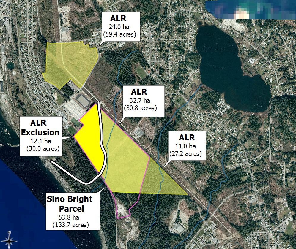
But the shape of the land-parcel did.

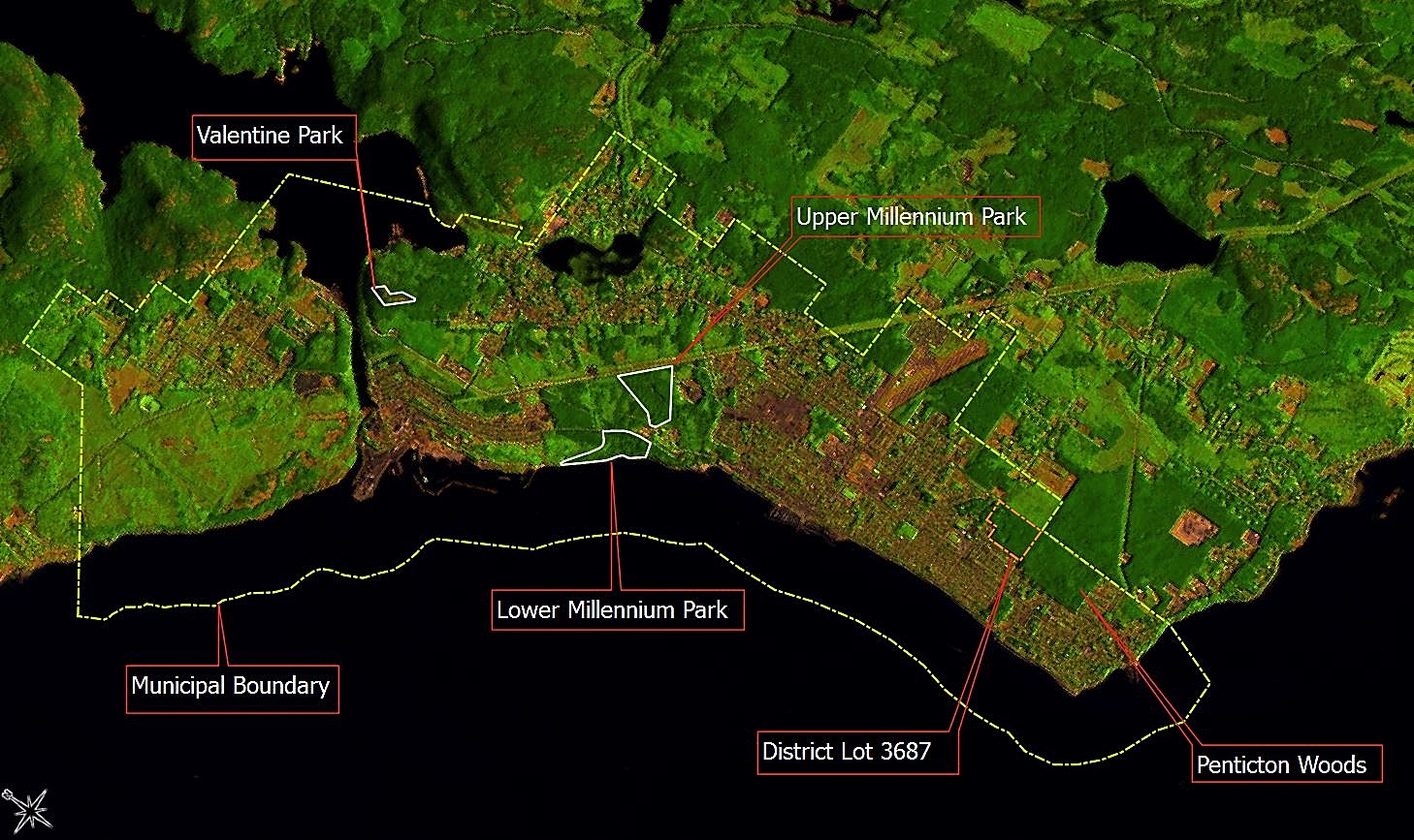
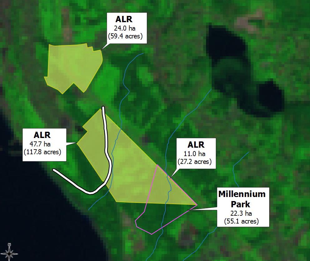
Consider the image above, which was recently posted on Facebook.  It didn’t make sense to me.  I’ve been studying these exact same land parcels for years…so to me it looked like a big bite had just been taken out of the southeastern corner of the upper parcel.

Aha. Here’s the bite. This is page 5 from the ALC Decison of March 26 2010.
I’d looked at this document before, but hadn’t realized that a land SALE was involved.

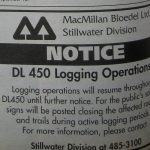
What is this…Shark Week?

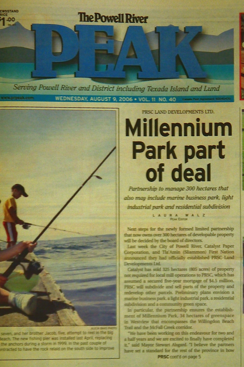
Thus I learned about another land sale by PRSC.  The details are simple enough.  PRSC sold 13.5 acres to Hatch-a-Bird Farm back in 2010.  As part of the deal, land was added to the ALR.

My Facebook informant helpfully reported that the ALR inclusion was a “condition of sale”.

Aha.  Because the sale involved ALR lands, an application was required – and a decision was made.  I’d seen that decision before, but confess that I hadn’t connected-the-dots (or georeferenced the map).

Fundamentally, what this meant for me is that I needed to fix all my  date-stamped maps.  Much cursing and gnashing of teeth ensued.
Oh well.

Hopefully the revised PRSC “land story” is more accurate than it was.

Digging into the books

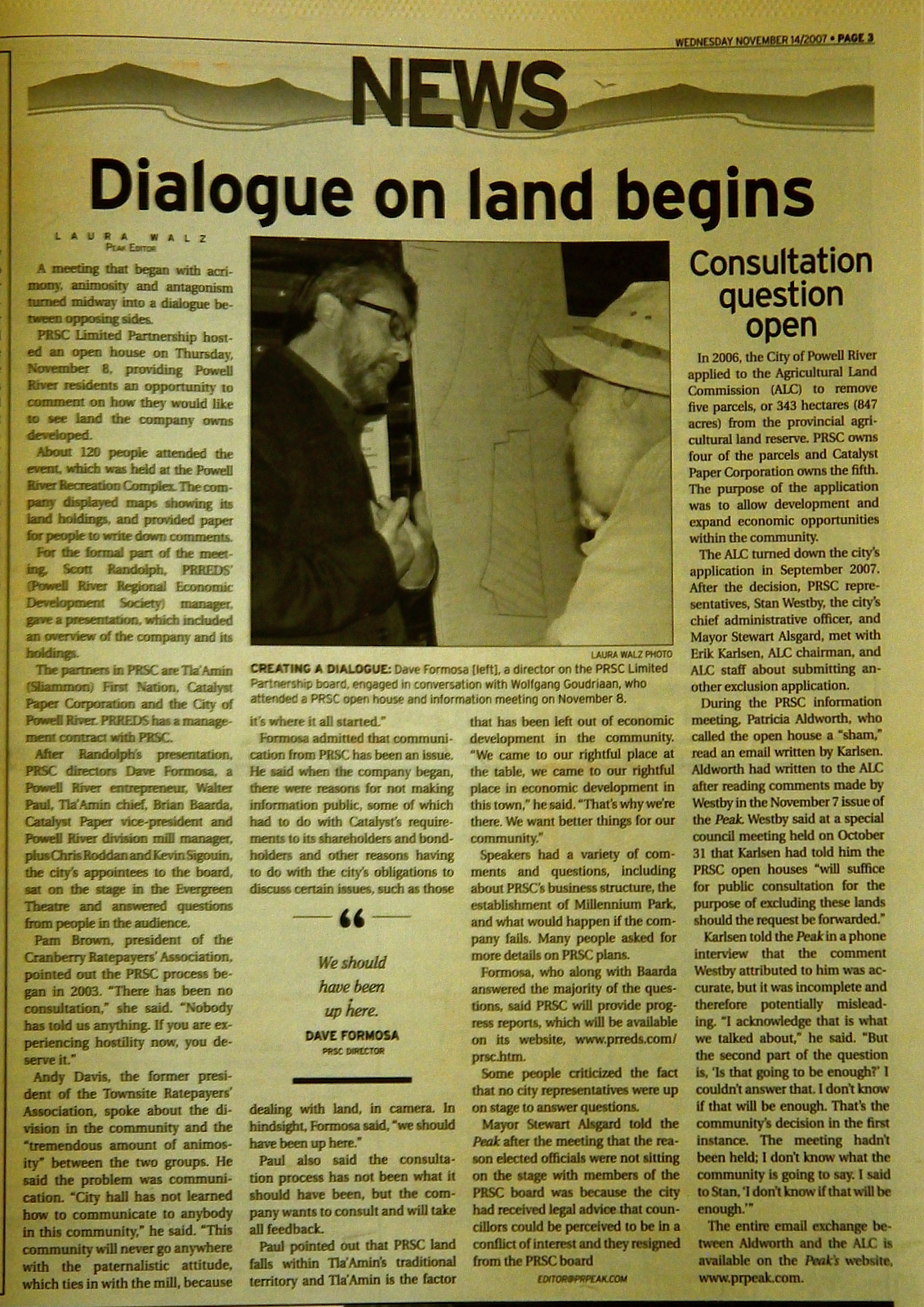
Elsewhere I’ve written about the desirability of having a “full accounting” of the PRSC experience.   I’m not alone.  Enter Pat Martin, who’s been pestering City Hall with Freedom-of-Information (FOI) Requests since she first appeared as a “Delegation” before the Committee of the Whole in January of 2019.

Pat has achieved some remarkable success.  For the first time we now have  PRSC’s financial books.  Or, more accurately, we have copies of their two sets of books.  Here they are:

PRSC Land Developments Ltd – Financial Statements
PRSC Limited Partnership – Financial Statements

Now if you’re like me, at first glance having two sets of books doesn’t make a whole lot of sense.  Then I thought about it some more.  Perhaps it’s like maintaining separate life-tables for males and females in a wildlife population – there might be sound reasons behind this division that are not easily appreciated by a layperson.  I accept that there might have been some reasons for this division – and I doubt we’ll ever learn what they were.

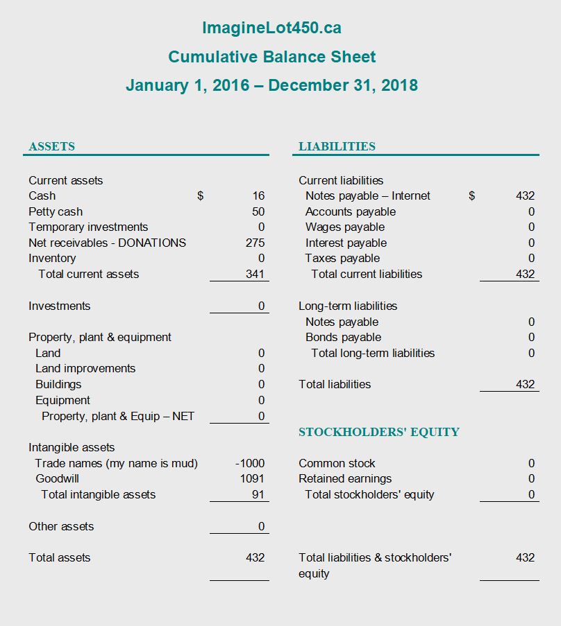
It doesn’t matter.  There are more interesting things to be found in the financial statements.  I began by calculating some basic statistics as follows:

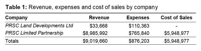
The first obvious conclusion from this is that PRSC Land Developments Ltd never sold any land.  Indeed this was the much smaller of the two PRSC entities, reporting a total of only $33,668 in “revenue” and $110,363 in “expenses” over 13 reporting periods (the PRSC “fiscal-year” ended on 31 March – and the first and last reporting periods were not “full years”).

PRSC Limited Partnership was the much bigger brother, with close to $9 million in revenue,  $876,203 in expenses…and a whopping $5,948,977 in “costs of sales”.

So taken as a whole, the combined PRSC enterprise showed a net profit of $2,194,480 from 2007 through 2018.  So far so good.

When did PRSC become profitable?
Figure 1: Annual Profit/Loss and Cumulative Balance as reported by the PRSC, 2007-dissolution.
The numbers are combined totals from the PRSC Limited Partnership and PRSC Land Developments Ltd.

Here’s a time-series with two variables.  Specifically, I’ve plotted annual “profit/loss” and a calculated “cumulative balance” against “fiscal year”.

This is quite revealing.  Apart from a small positive “blip” in 2008, PRSC carried a negative balance until its final year of operation in 2018.

I’ll say it again: PRSC only became profitable in its final year of existence, after previously-unsold lands were acquired by the two remaining partners.

I’m still confused by this.
Did money actually change hands in 2018?  Or was the “appraised value” of land used to create the appearance of a “profit” at time of dissolution?

Land sales and profits over time

Now that an “end-of-game” scorecard has been obtained…
How much did PRSC actually earn by selling all those ex-Catalyst “surplus” lands?

Figure 2: Profits and costs of land sales by PRSC Limited Partnership, 2007-dissolution.
This graphic omits “revenue” reported as “cost recovery” or “forfeited deposits” in 2015 and 2016.
The bottom line is that it cost $5.9 million to sell lands worth $8.6 million.

I explored this question by focusing my attention upon the Limited Partnership and selecting only those fiscal years in which “costs of sales” were reported.

In scientific terms, I “constrained the sample”.  Thus I ignored revenues from “cost recovery” (FY2015) or “forfeited deposits” (FY2016).  I don’t know what those mean, and I wanted to compare apples with apples.

There were six years in which PRSC reported “costs of sales”.  The bad news for PRSC shareholders is that these costs were 69% of the gross value of the lands.  In 2010 they lost money (-$20,427) on lands that sold for $1.76 million.  In 2017 they earned only $16,939 from the $330,000 sale of Wildwood Hill (this represents the only instance in which it’s possible to tie revenues to a particular land sale).

I’m frankly dumbfounded by figures such as these – but maybe there’s a reasonable explanation.  Unfortunately the financial statements provide no details about how “costs of sales” were calculated.  The bad news for me is that I’m unaware of any land sold in 2008, but the data suggest there was – so I may be needing to update all my date-stamped maps again when that information becomes available…
aaargh

Filling in the blanks

The financial records unfortunately don’t break down revenues by property.  Period.   The result is that it becomes impossible to ask questions about “good property deals” versus “bad ones”.   Nor is it simple to reconcile financial records with those from other sources.  A few examples will illustrate the difficulties.

We know, for example (from the MLS listing) that the property that became Timberlane Estates sold on 10 March 2009 for $260,000.  This sale doesn’t show up in the FY2009 report for the Limited Partnership, even though their “fiscal-year” ended on 31 March.

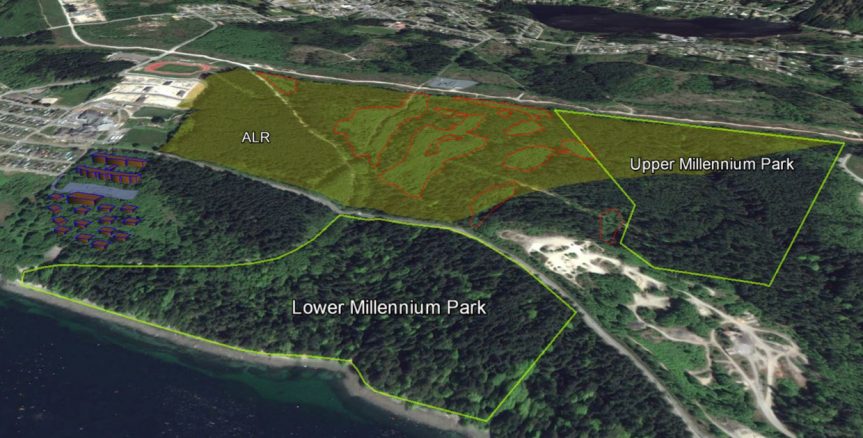
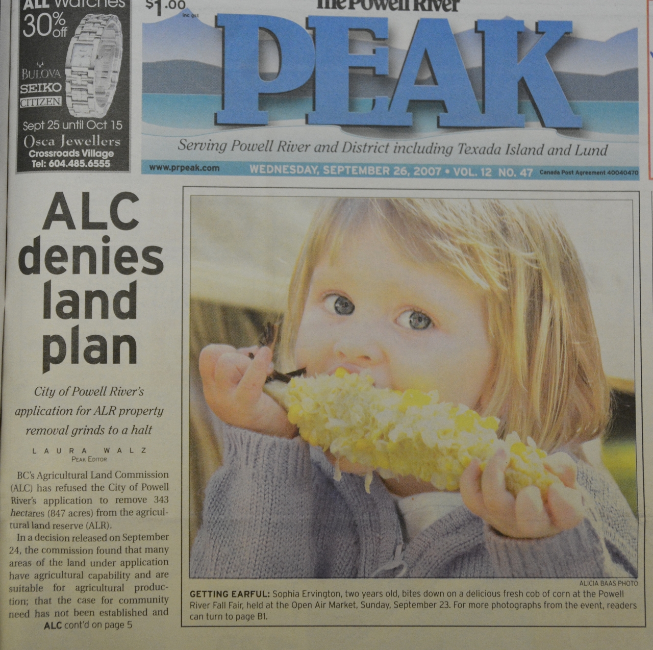
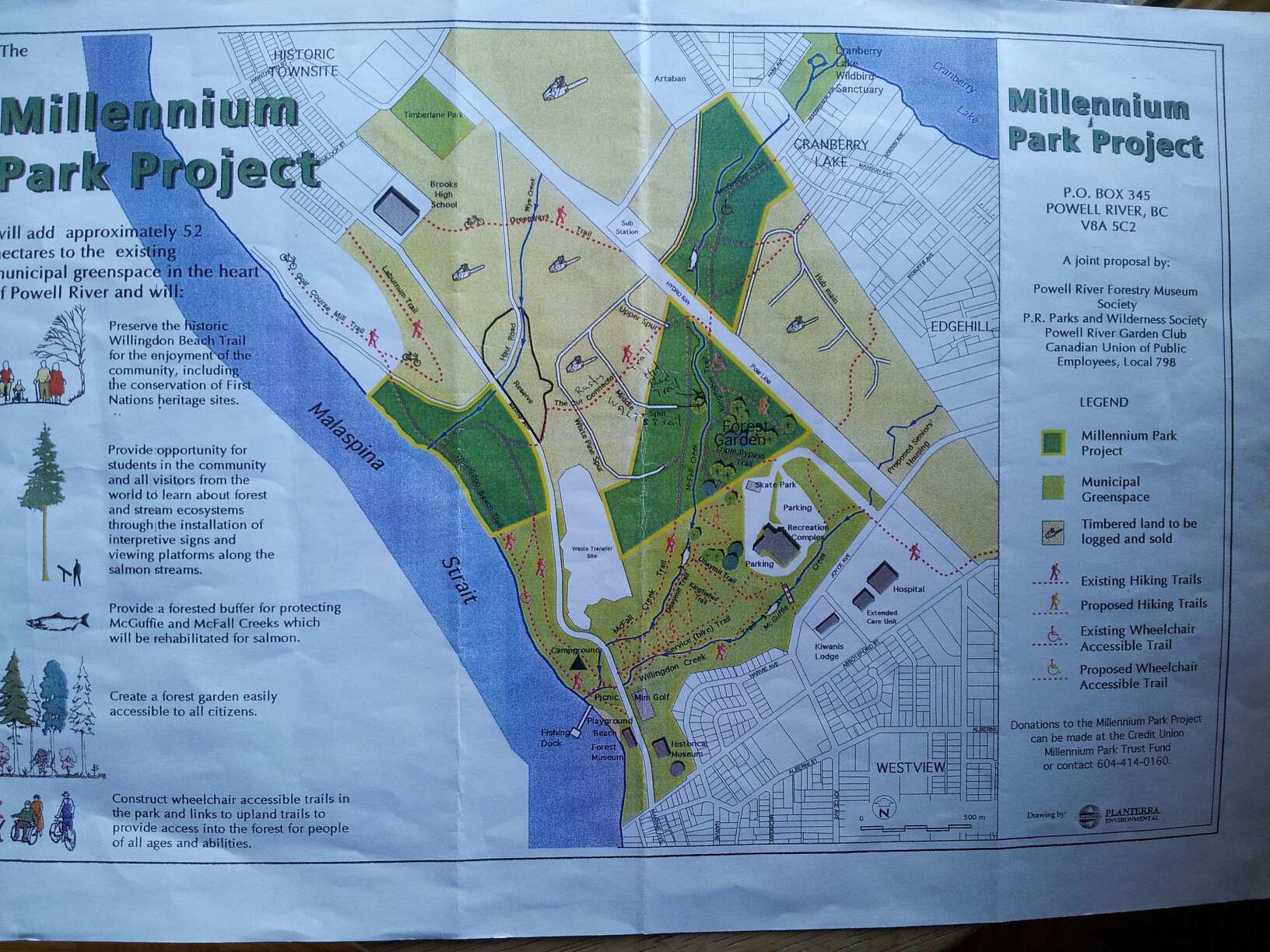
The FY2010 report shows that year to have been a relatively good one – with $1.76 million worth of sales.  Approximate dates are known for some of these sales.  Millenium Park sold in 2010 (the Peak announced it on Feb 10th), as did the 32 acre “farm in Cranberry” (the Peak reported that on Jul 21st), and Hatch-a-Bird Farm (Facebook in 2019).

Allowing for some delay in “the paperwork catching up”, I think it’s reasonable to make informed guesses about what must have happened.  Accordingly I pooled the data for FY 2010 & 2011 revenues, looked at the listing and selling prices for the properties that I knew about, and guessed at the ones I didn’t.   The result looks like this:

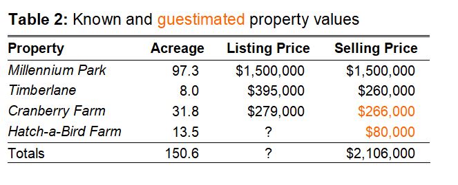
That gets me pretty close to the reported total of $2,106,550 for the two years.  None of it, however, explains the ginormous costs of sale ($2,057,035) or the puny profit that ensued ($49,515).

Will it ever end?

There are numerous other oddities and inconsistencies to be found throughout the PRSC financial records.

There’s a substantial accounting error in the 2018 PRSC Land Developments Ltd statement caused by adding two negative numbers incorrectly.   The value of the PRSC “Land Inventory” goes up in some years – by adding the cost of property taxes paid.  Yes.  You read that correctly.

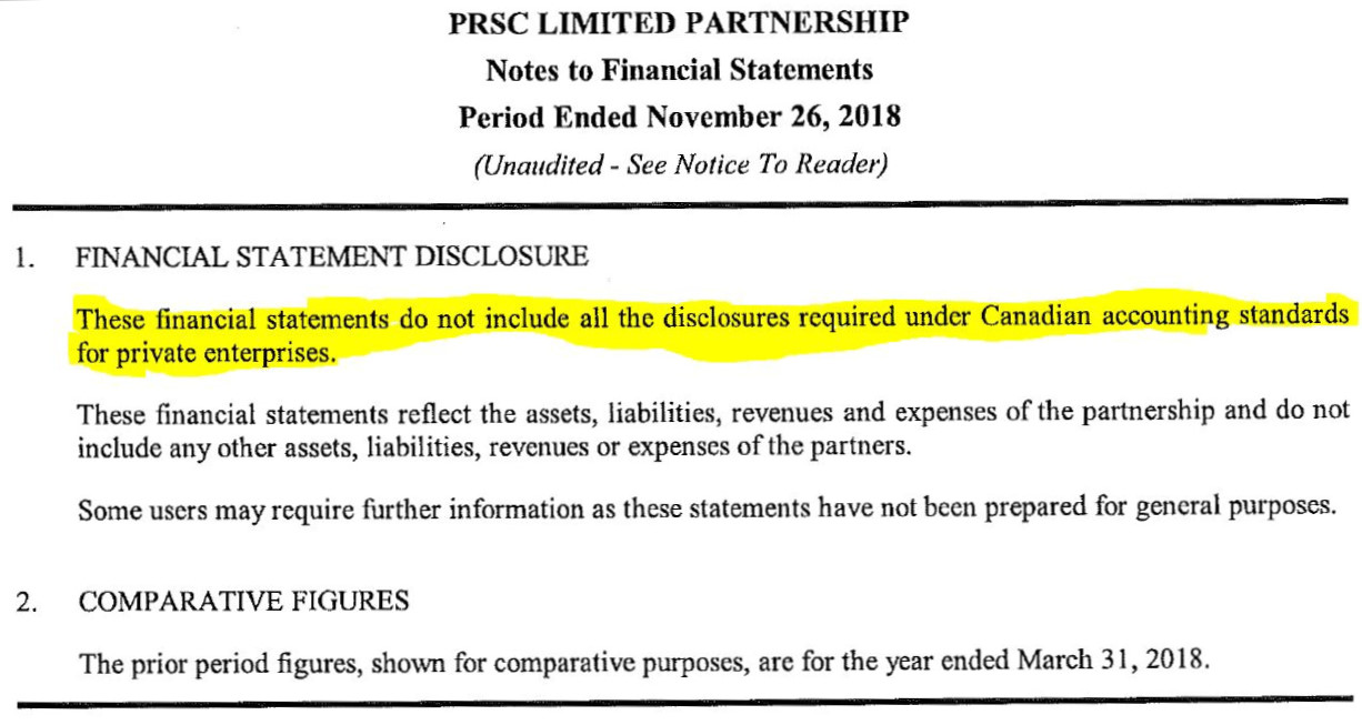
I note that the PRSC financial statements were audited for only two of the 13 reporting periods (FY2007 and FY2008).   Subsequent statements were unaudited and contain wording like this  – a situation I don’t find comforting at all.

So I think some kind of a retroactive audit is long-overdue…if for no other reason than to save us from doing the same thing over and over again while expecting a different result.

In essence?  Having explored things in some detail, I think the taxpayers of Powell River got hurt.

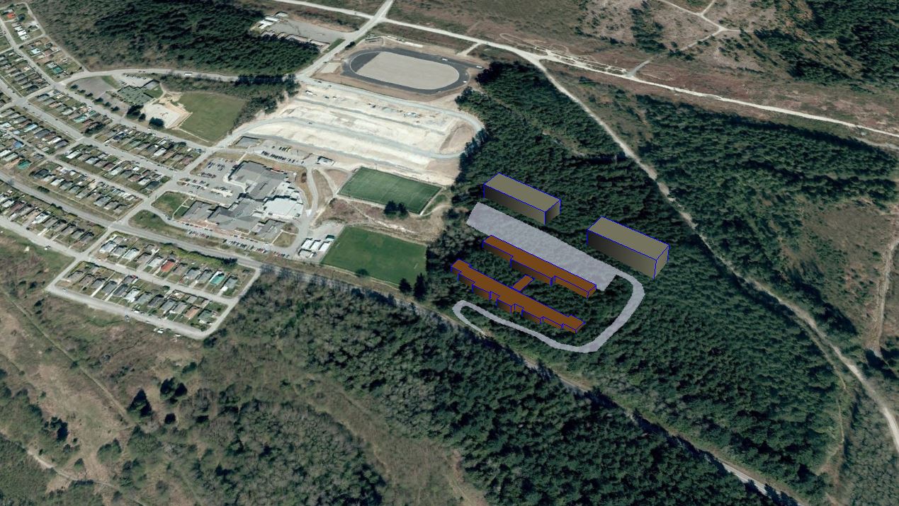
PRSC was ill-conceived and sloppily managed.  There were promises but no real attempts at “transparency”.   It shouldn’t have taken FOI requests to obtain financial records, it shouldn’t have needed “social media” to learn about land sales in 2010, and it shouldn’t have been possible to build a road on the ALR to service the neighbour’s housing development…especially when the “neighbour” was also a “Founding Director”.

I remain saddened that we collectively seem to want to avoid recognizing the fact that these were mistakes
– and we might learn from them.

Meanwhile, Peter Gabriel is still digging …in my head at least.

PRSC: why groundhogs & accountants matter

Adult female (Marmota vancouverensis) at emergence, Haley Lake Ecological Reserve, 29 April 1996 - A. Bryant
What Groundhog Day really looks like.
Here’s an adult female Vancouver Island marmot (Marmota vancouverensis) photographed at Haley Lake Ecological Reserve, 29 April 1996.  She’s just burrowed through about 2 metres of snow to see daylight for the first time in about 210 days.  Judging from the footprints, I missed her emergence by a few hours.
Forensic accounting is hard.
The PRSC is history

So we move on.  As is true in matters of love, sports teams and haircuts, I think humans are optimists by nature, reasoning that things just have to get better.

Because we’re smarter now, right?
We’ve learned from experience, right?
Sadly, history teaches us that this is not always true.
And as Bill Murray so wonderfully showed us, sometimes it takes more than a few successive Groundhog Days before the lessons truly sink in.

Accounting 101

This is where things become interesting.  Were I an accountant, I’d start by asking questions like:

  • where’s the balance-sheet?  After all, PRSC was responsible for a large chunk of “Lot 450” from the time of its inception until its dissolution in 2018.  How much money did it make?  How much did it lose?  In financial terms, was PRSC a successful business?

But I’m an ecologist, so I don’t think in purely financial terms.  Indeed my training and curiosity demands that I also ask:

  • where’s the ecological balance-sheet?  Are conditions on the land better than they were?  Have the PRSC subscribed to “best standards” in terms of managing the lands during their decade of landownership?  Did they show vision?

Lastly, I’m a taxpayer, resident of Powell River, and amateur historian.

  • where’s the social balance-sheet?  What did PRSC do to us?  What did it do to trust in our local government?

So.  We don’t need a “balance-sheet”.  We need three of them.  Here goes.

The Financial balance-sheet
Here’s a typical accounting balance-sheet (in this case from a fairly unsuccessful enterprise)

In a perfect world this would be easy.  Tally income from land sales, deduct expenses, factor in land appreciation/depreciation over time, and come up with a dollar value.  Governments do it all the time.  Businesses do it all the time.

But because PRSC was structured as a Limited Partnership with three shareholders (two after Catalyst left), well this gets harder.

I would assume that PRSC provided such reporting to their shareholders.  But to my knowledge there’s been no publicly-released balance sheet – ever.

So we’re left trying to guestimate from what we do know.  This is not a happy state-of-affairs for someone like me, who loves data.

“Millennium Park part of deal”
This is the earliest published reference that I can find for the PRSC…despite having been established three months earlier, in May.
Powell River Peak, 9 Aug 2006

PRSC sold three properties on the “open market” (Timberlane Estates, Cranberry Farm and Wildwood Hill).  One sold for $260,000 (Timberlane), and another for $330,000 (Wildwood Hill).  We know of other deals that came up – and fell through.

It’s not hard to find references to “accepted offers” or “interested buyers” here and there.  But in the end, that was it.  The PRSC sold three properties on the “open market”.

We also know that the City aquired PRSC lands.  Millennium Park was part of the provincial deal struck when Weyerhaeuser bought MacMillan Bloedel back in 1999 – that’s what made the headlines when PRSC was first announced six years later, in 2006.

There were two other properties aquired by the City.  What I still call the “Sino Bright parcel” was purchased in 2017 (for $800,000), as was a portion of “Waterfront A” (for $175,000).

Some early questions about the “Joint Venture”
The above is from the “Watchdog Bulletin”, Vol. 1 ,Issue 1. , which was published in February of 2006.

It’s impossible to build a balance-sheet from these data.  We know nothing of property taxes paid, or interest, or any of the other line-items that make up a typical financial balance-sheet.

The lack of fiscal transparency made PRSC controversial from the start.  Patricia Aldworth, whom we’ll meet again, published a series of email newsletters in 2006-2007.  Many of these were focussed on what she called the “Joint Venture”.

Never one to mince words, Ms. Aldworth was asking tough questions right from the start.  Thirteen years later, what strikes me about her list was specific reference to:

“legal and financial risks to taxpayers” and
“public reporting of financial position”.

Because, in the end, we got a whole lot of the former, and none of the latter.

So.  Was PRSC a successful business in financial terms?
The “preponderance of evidence” would suggest “NO”.
Did PRSC put taxpayers at “legal and financial” risk?  “YES”.

The Ecological balance-sheet
This is the City-proposed ALR exclusion made as part of the Yrainucep proposal of 2006.
Despite the fact that proposed development involved no lands south of Wildwood, the feeling appears to have been “well, if we’re going to apply for an ALR exclusion…why don’t we ask for all of it?”

PRSC seldom made decisions with ecological principles in mind – but to be fair, that was never their mandate.

There are some successes to report.  First and foremost is Millennium Park.  It was forced upon them, admittedly, but they didn’t hinder it.  And while options were discussed, no forest harvesting occurred within it.

Many of the PRSC lands were part of the Agricultural Land Reserve (ALR) – and here the report-card is not so favorable.  Indeed, the ALR was generally considered to be an impediment to what were perceived to be the “highest and best use” of land.

If you take time to read the ALC Decision, it was Yrainucep that “anchored” the City’s application to remove 343 hectares from the ALR – even though that development only concerned lands in Wildwood.

But as Dave Formosa, then on the PRSC Board of Directors and also President of the Powell River Chamber of Commerce,  put it:

“If we don’t take it out of the ALR, how can we move forward?  What was the purpose of the whole thing?”

Yes.  Maintaining forests, agricultural potential, biodiversity, and life-support systems on Planet Earth can be a right pain-in-the-ass.

Here’s one of the clearcuts made by MacMillan Bloedel/Weyerhaeuser contractors way back in 1999-2000 on what I still call the “Sino Bright parcel”.
Forest conditions (and land values) could have been improved under the watch of an astute landowner.

So far as I can determine, there were no serious attempts made to “improve” the lands under PRSC control during the twelve years of their tenure.

For example, there were no efforts to treat the post-harvest patches that were harvested by MacMillan-Bloedel & Weyerhaeuser in 1999-2000.  These are now overgrown thickets of blackberry and alder instead of healthy young forests of fir and hemlock.

Nor was there any made to pursue the legal question raised about tree ownership, as reported here.  So far as PRSC was concerned it was simpler just to accept that “Island Timberlands owns the trees”.

And then there’s the “looped road” issue.  This frankly just baffles me.  Quite apart from the ALR transgression, this was effectively giving away 2 acres of forested land.  Or…was it given away?  We don’t know.  That’s not on the public record either.

Ultimately, from an ecological perspective, I think two broad conclusions can be safely drawn.

  • the ALC was effective in “watching our back” and prevented more substantial damage to the lands in question, and
  • in terms of ecological “stewardship” or “vision for the land”, PRSC was pretty much “asleep at the wheel”.
The Social balance-sheet
PRSC hosted two “open houses” in November 2007.
Alas, this was “too little, too late” to alter public opinion on the subject.
Indeed, Yrainucep Development Corporation had announced their departure from land consultations – a week earlier.
Powell River Peak, 14 Nov 2007

This is perhaps the “meat” of it.  It’s not my “area of expertise” – I’m neither a psychologist or sociologist.  But I think someone needs to say it.  The true cost of the PRSC has been the loss of trust in local government.

  • Prior to public announcement of PRSC in 2006, there was already a major land development “in the works”.
  • Prior to the announcment of Yrainucup, there was already an ALR exclusion application “in the works”.
  • Simultaneously a Director of PRSC was in the process of suing an individual who, so far as I can tell, was merely trying to inform people about matters of public policy.

Fast forward a few years to 2015, and now there’s a new deal on the table: Sino Bright

This time around lessons have been learned.  Public hearings on the ALR exclusion are held.
After an agreement to sell the lands had already been made…and after people have noticed that there’s a suspicious-looking road on the ALR, and that the proposed exclusion would make
the problem go away.

I could go on…in recent months there’s been another land-sale to Sino Bright, which was signed on the same day that PRSC dissolved itself.  Coincidence?

In the end

Perhaps it’s fitting to wrap this up with another gem from the Peak:

“This is what has been missing from the whole process all along: public input, a way for the public to feel consulted, if not involved in decisions that impact their community.  A dialogue has begun and hopefully our elected officials will not only realize this is a necessary part of the equation, but will act to expand the conversation.”

That’s from an op-ed published on 7 Jan 2007.

Welcome to Powell River.
Where every day is Groundhog Day.

House of dark shadows: requiem for the PRSC

“On finals at YDC”. This is the international airport as envisioned in the 2006 Yrainucep proposal  
The location and dimensions are accurate – I georeferenced a map, created a runway shapefile and uploaded that to Google Earth so I could see it. The planned over-run of Highway 101 at the far end is also accurate. The cockpit-view is of course fake, as is the runway lighting. My too-shallow landing approach would have yielded an “F” grade from my flight instructor.
But we’re talking about the PRSC here. Seen through the lens of history, the “joint venture” was seemingly incapable of recognizing its own “failed-approaches” over time.
Context

When I first built this website to “map things” so I could better understand land and forest ownership issues, I wrote:

  • “There are three major landowners: Catalyst Paper, Island Timberlands, and the PRSC Limited Partnership.
  •  Together these three entities own about 29% of the land contained within city limits, and 64% of the original Lot 450 . 
  • The history of land ownership is convoluted, but these three “big players” are the reason why this website is designed the way it is.”

That was then.  My map-making skills have improved somewhat.  And rather a lot has happened since those first heady “stop-the-cut” days of 2015.  But I didn’t anticipate this:

The PRSC is no more
2006 PRSC landholdings
Here are the land parcels transferred from Catalyst to the newly-formed Powell River-Sliammon-Catalyst (PRSC) Limited Partnership in 2006.  Some parcels contain a “foreshore lease” – so some of the lands are submerged.

It’s true.
Quietly and without fanfare, the PRSC Limited Partnership has dissolved itself.  Behind closed doors.  Admittedly there were clues that this was going to happen.

Indeed the Peak reported, way back in April, that the writing was on the wall:

“Tla’amin is proposing that it and the city dissolve PRSC Limited Partnership, a joint venture between the city and Tla’amin’s Tees’kwat Land Holdings, with each entity holding a single share.”

I kept looking for, without success, some “official” notification that this had actually happened.  I couldn’t find it in the Peak or in City Council documents.  And as has happened before, several links to external documents from this website simply “disappeared” overnight.  Panic set in:  my goodness, now I’ll have to redraw my maps and redesign the entire website!   No.  That won’t happen.  Why?  That’s easy.
But I digress.

In the course of looking for other stuff, land title searches revealed that ownership of the Old Golf Course and Gibson’s Beach properties had changed on 14 September (with the golf course going to the Powell River Waterfront Development Corporation and Gibson’s going to Tla’amin Nation).  Exactly as the Peak had reported.

Dissolution of the PRSC, as reported in Neh Motl (November 2018)
As official as it gets…
Click to enlarge

Social media reported on 15 January that “a search of company records indicates that on December 11, 2018 PRSC was dissolved.”  That may be true.  Perhaps one day a kind reader will share that document so I can post it here.

For me, the final piece of the puzzle arrived just a few days ago, when a colleague pointed me to the November issue of Neh Motl, the Tla’amin Nation newsletter.

Sure enough, there it is, on page 15.  The final PRSC meeting occurred three days before land-transfer applications were received by Land Titles.

So.  The PRSC is gone.

My first question is: so what did the PRSC actually do, and when did they do it?  Forgive my scientific training – but that needs a timeline, methinks.  Here goes:

The PRSC Timeline

*  Trust me – you’ll want to see this fullscreen.  Your browser will open a new tab and it’ll look much nicer that it does when confined to the box below.  Hint: You can scroll through it using the arrows, or jump to a particular spot on the timeline.

**  I designed this to be a live dataset – to be easily updated as errors and omissions are found and reported.  Be brutally critical – and send me an email.  My hope is that what remains will stand the test of time.


Whew!  I think that’s enough for one arm’s length limited partnership.  More soon.

The wheels of government move slowly: more about that illegal road

Location of the illegal road on the ALR, Hemlock Street, Powell River - A. Bryant
This is the infamous “looped road” at the top end of Hemlock Street. This Google Earth aerial photo dates from 17 April 2011. The road is complete but not yet paved. I converted and uploaded a shapefile overlay from the ALC to illustrate the transgression.

The wheels of government move slowly…
but they do move…
and sometimes, if you insist on standing still, they’ll run over your toes!

This story has been a long time brewing.  I’ve written about it before, here and here.

Way back in 2010, a local developer managed to construct an illegal road on a neighbour’s property…it’s illegal because said neighbour’s property happens to be within the Agricultural Land Reserve (ALR).

Oops.

The story made the Powell River Peak in March 2018 under the headline “City of Powell River hits roadblock with land commission“.   Three weeks later I appeared as a “delegation” before the Committee of the Whole (COW).  My presentation was perhaps optimistically entitled “a possible resolution of ALR woes“. 

You can view it by clicking on the photos at right.  In retrospect, it wasn’t my best effort.  I went over-time and got bogged down in historical detail.  I should have started with the solution first.  In any event, the idea flew like a lead balloon and didn’t land well.

My idea was a what-if?
What if the collective “we” went back to the Commission and said:

“listen, we messed up…we really did…but hey…
Rather than point fingers or inconvenience hundreds of people who use that road daily by tearing it up…not to mention the huge costs involved in doing that…
Why don’t we build that treatment plant on the Old Golf Course just as we planned…and then ask to transfer the remainder of those lands into the ALR?
Wouldn’t that be a more appropriate, progressive, scientifically-valid, and mutually-beneficial penalty that completely acknowledges our screw-up?
Pretty-please?”

The idea went nowhere.

Wow!

So here we are six months later.  It’s November.  Just when I should be thinking about important things like Christmas Bird Counts and Black Friday and such, fate intervened.  Several documents found their way into my mailbox.  They are as follows:

  1. Internal report from David Assels (Compliance and Enforcement Officer) to Kim Grout (CEO, Agricultural Land Commission) dated 18 Oct 2018,
  2. Attachments to said report, including photographs, maps and prior correspondence dating back to 2016, and finally,
  3. Remediation Order to the City of Powell River dated 22 Oct 2018 but based on a decision apparently made earlier.

I encourage readers to examine all of the documents in full.  If you’re in a hurry, perhaps the key point is best expressed on page 4 of the Remediation Order, which states:

There’s even a deadline.  Or, more precisely, two deadlines:

  • The “removal of fill” and a “report by a qualified professional” needs to happen “no later than Feb 28, 2019”.
  • “The above requirements must be completed by August 31, 2019 unless prior to that time,  I agree in writing to vary this Remediation Order.”
Ouch.

Now that’s gonna leave a mark.
In financial, legal and (most stupidly of all) in ecological terms.
Personally, I think mine would have been a more elegant solution…

But that’s just my opinion

Now, about that Christmas Bird Count…

We’re still waiting for some effective leadership on that front too…

Incubator farms, fuel loads and toads: what just happened?

Proposed Incubator Farm location, District Lot 3687, Powell River, BC
Figure 1: Location of the proposed Incubator Farm: District Lot 3687.   The lot is 50 acres (20.4 ha) in size, and along with adjacent Penticton Woods, is owned by the City.
This Google Earth image also shows the municipal boundary, the Agricultural Land Reserve (ALR), and older forests classified as Old Growth Management Areas (OGMA).
Buying the farm

The “incubator farm” idea has been shelved – because “farming groups said they were not in favour“.

I have no opinion about that.  Incubator farms seemingly work really well in some situations.

But a couple of other things caught my eye when I looked again.

Incubator farm location

The “New Ground” proposal as crafted by the Powell River Educational Services Society (PRESS) makes no mention of the “Sino-Bright parcel” on Lot 450.  That really surprised me – because according to the public meetings I attended, that’s where it was slated to go. For example, on 6 June the Peak reported that:

“The location of the incubator has yet to be decided, but [Mr.] Randolph said its preferred location is within the residual agricultural reserve land that Sino Bright School BC (SBSBC) intends to purchase from PRSC Land Development, a corporation owned by the city and Tla’amin Nation, if that deal goes through.”

Forest cover within Powell River, BC, as of 20 April 2016
Figure 2: Remaining mature forest within Powell River City limits as of 20 April 2016.
This Landsat 8 image uses bands 7-6-4, making mature forests appear very dark green.
Built-up urban areas and new cutblocks appear reddish-brown, while regenerating forests appear as very light green.

In fact, the New Ground proposal considered only a single area: District Lot 3687.  I didn’t know where that was, so had to look it up.

Zooming out at bit (Landsat flies 705 km overhead), we can see that:

  • DL 3687, combined with adjacent Penticton Woods, is one of 3 large blocks of forest remaining within city limits.
  • Along with Millennium Park, the area is the only substantial chunk of forest owned by the City.
  • These and other lands (the Sino-Bright parcel, and the Valentine/Pole-line PMFL) represent a last chance – to realize the original “garden city” vision of a community surrounded by a “green belt of trees and parkland”.
Andrew Bryant on Lot 450 PMFL, 12 May 2015
I don’t often wear hi-viz when conducting “global inventories of flora and fauna”, but when I do…
it’s always somebody else’s

Other elements of the New Ground proposal deserve mention.  The cost of tree-cutting and stump-removal wouldn’t have been trivial – $240,000 to get 20 acres “into production”.   But I cringed to see that forest described as “vacant land”.

I did like the idea of a “global inventory of flora and fauna using or occupying site and bordering areas”, but that item didn’t merit a line-entry  in the budget.  Some apparently believe that such inventories are easy, or cheap.  They’re not.

In any event, the incubator farm idea is on hold, and I suspect it’s unlikely to re-emerge for the Sino-Bright parcel either.  I don’t mind.  From my perspective, converting healthy forests into marginal cropland is intrinsically a bad idea.

But what still really irks me is this:

Once again a major land redevelopment was contemplated – one that would have involved clearing a large forested area – and that fact wasn’t made part of the public discussion.

Fuel loads, wildfire and biodiversity
Pileated Woodpecker, 20 Dec 2016
Pileated woodpecker at Penticton Woods, 20 Dec 2016.

A second issue became apparent during walks in the area for the Christmas Bird Count.  The birds were nice, but mostly I was struck by the evidence of recent brush-clearing.  The impacts were both obvious and extensive.

Time for more research.

It didn’t take long to figure things out.  Back in 2014, the Regional District had enlisted a consulting firm, Blackwell and Associates, to prepare a Community Wildfire Protection Plan.  Said plan, which you can read here, is both thorough and detailed.

In a nutshell, the report sought to map the Regional District in terms of “fuel loads”.  The idea is that the risk of damage to property through wildfire can be minimized if you manage those loads.  Makes sense.  Nobody wants another Kelowna or Fort McMurray disaster in the “wildland-urban-interface”.
Accordingly, one of the recommendations was:

“The Regional District should work with forest operators (e.g., licensees, woodlot operators, private land owners, etc.) to reduce fire risk in their operating areas…”

Things moved quickly, as was reported by various sources on 21 March, 21 Sept and 12 Oct of 2016.  That’s why parts of Penticton Woods and District Lot 3687 look the way they do (see the slide-show at upper right).

Western toad (Bufo boreas)
The Western toad (Bufo boreas) is a “blue-listed” species in B.C. Like most, this species is utterly reliant upon a variety of habitats to satisfy life-history requirements.

That’s also why my recent rambles in the woods made me think long and hard about Pacific Wrens, Wilson’s Warblers, mushrooms, beetles, ants, frogs, salamanders and, yes, toads.

There’s a wealth of scholarly work on the effects of forest understory removal upon low-nesting birds, small mammals and, in particular, amphibians.

One 2004 review of studies from forests in the Pacific Northwest concludes that while more scientific work on the subject is needed;

“Today, the challenge is to maintain biodiversity in western forests in the face of intense political pressures designed to “prevent” catastrophic fires.”

The bottom line

The key issue here, as is often the case, is whether it’s a good idea to make land decisions based on single criteria, or a single report.  Removing “downed and woody debris” is a good prescription for eliminating fire hazard, but will pretty much ruin the habitat for many other species.  Standing snags are dangerous for fallers, but critical for cavity-nesting birds. Incubator farms are great if they help young farmers get into the farming business – and silly if they don’t.

Whew…
….I’m so glad I got that off my chest

I can’t help but occasionally feel like Sisyphus, wondering when or if we will collectively “get it”, and realize that the value of an urban forest is more than just logs to the barge, or fodder for the next brilliant idea about what to do with “vacant land”.

Because…It’s…Not…Vacant…Land

. (period)

If a tree falls in the forest: will the Supreme Court hear it?

Upper and lower Millennium Park, the ALR and proposed ALR exclusion, and an alternative site location for Sino Bright School in Powell River, BC
Plan C:
With ALR exclusion off the table, maybe it’s time to re-think what the “Green Heart of Powell River” could be – if the trees don’t have to come down.
This image shows the ALR surrounded by upper and lower Millenium Park – it also shows the areas harvested in 1999-2000 – and what Sino Bright could look like if re-positioned on the old golf course.
State of denial

The recent Land Commission decision to deny exclusion of ALR lands came as a shock to some – which puzzles me.

Given events in 1994 and 2006, Powell River has a history of asking for ALR exclusions on the basis of “community need” – and then not providing a very compelling case for them.

The ALC decision is available here.  Briefly, it says a) there is some modest agricultural potential on the land, and b) there was no detailed analysis of other potential locations.

In essence the ALC asked, as others have (e.g., herehere and here); why did Sino Bright School have to be built on the ALR?   Their decision is admirably brief:

“The Panel finds that the Proposal would be more appropriately located on lands outside of the ALR.”

I agree.  And I really, really hope that the PRSC, VIU, School District 47 and Sino Bright were far-sighted enough to have envisioned the need for a Plan B.  

Background

Elsewhere I’ve described the history of what I call the “Sino Bright parcel” and other PRSC lands, much of which was shaped by MacMillan Bloedel’s subdivision in 1998.

mb_1998_licence_signed_small
Geoffrey Mynett signed on behalf of the Licensor and the Licensee.
Click to read the full licence.

To recap, one branch became the pulp and paper division (558654 BC Ltd), while the other kept the M&B name and forestry operations.  Thus we have the amusing case of one person signing both sides of a contract, in which the Licensor (558654 BC Ltd) granted one-time rights to the Licensee (M&B) to “harvest and remove the timber growing on the land as of May 31st 1998.”

There’s nothing untoward about this – it was a simple corporate restructuring.  Nor is it odd that the licence was renewed a year later, when 558654 BC Ltd became Pacifica Papers.  What was, I think, utterly unexpected was the takeover of M&B by Weyerhaeuser, four months later, in November of 1999.

Here’s where it became interesting to me, in light of the wording of the 1998 licence and the 1999 affirmation that:

“Licence terminates upon harvesting of timber in accordance with harvesting agreement between Pacifica and MB”

The satellite imagery is unambiguous.  Logging of the Sino Bright parcel and adjacent properties began in October of 1999 (under MacMillan Bloedel) and continued until April of 2000 (under Weyerhaeuser).  About 25% of the trees were harvested.  From the best soils on the property.

Man stands for Lot 450 Powell River Peak, December 16, 1999
Man stands for Lot 450
Powell River Peak, Dec 16, 1999

The takeover didn’t change much on the ground.  It was the same loggers, the same trucks and chainsaws, that started and finished the job.  There was no real difference – it was the same forestry operation – only with a different corporate address.

As always, the Peak dutifully recorded these changes. There wasn’t much public outcry – but there was some.

The legal question

In August of 2016 I was encouraged to contact one Andrew Gage, a lawyer with West Coast Environmental Law.  As is my nature, I supplied him with far more data that he probably expected.  In turn he agreed to study the issue and form an opinion.  Further, he agreed to write a letter on my behalf if he thought the situation had legal merit.

Letter from West Coast Environmental Law to the PRSC and shareholders, 14 September 2016
Click to read the full document.

Here’s Mr. Gage’s letter.  It was mailed on 14 Sept 2016 along with Exhibit Awhich illustrates the same cut-blocks shown above.

According to the 1998 licence, there should have been a “mutually agreed-to harvest plan” prior to any trees coming down.  Trees came down, so I think it’s reasonable to assume that there was some kind of a harvest plan.

The licence also states: “Any remaining timber not harvested by the Licensee at this time will belong to the Licensor.

I think the key issue raised here is: at what point are “partly-exercised” rights conferred by a licence considered to be “expired”?

The opportunity

Andrew Gage’s central point is that a “proceeding brought by petition” under BC Supreme Court Civil Rules could be a relatively inexpensive means of clarifying the question of “who owns the trees?”  And that PRSC Limited Partnership Ltd, and by extension its two shareholders, have a moral, legal and fiduciary responsibility to do so.

His letter even outlined the necessary “next-steps”.

BC Supreme Court Civil Rule 2-1(2)(c) applies when

the sole or principal question at issue is alleged to be one of construction of an enactment, will, deed, oral or written contract or other document;

BC Supreme Court Civil Rule 2-1(2)(g) relates to land and seeks

(ii) a declaration that settles the priority between interests or charges,

The ramifications

I confess to having become excited by the possibilities that the foregoing raised.

  • What if the ALC denied the application for exclusion, and the Sino Bright land sale fell through as a result?
  • What if a Supreme Court Judge were to rule that yes, the evidence is that one-time harvest rights were exercised, and rights to the remaining timber reverted to the Licensor, and are therefore not held by Island Timberlands?
  • What if it turned out that a substantial chunk of forested land – bordered by upper and lower Millennium Parks, a soon-to-be rehabilitated incinerator site, and Brooks Secondary School – didn’t automatically have to be clearcut?

Once upon a time I did a radio interview in which I described myself, and this website, as being “unimaginative”.   Well, here goes.  I’m calling it Plan C.   Whaddya think?

Accordingly, in September I followed up with a few phone calls – followed by individual emails to the Mayor and City Councilors in October.

I’m still waiting to hear back…

Responsiveness in government: a tale of four letters

The infamous Lubyanka, home of the KGB - and also home to the Russian Ministry of Interior. It was a strange place to find responsiveness in Government
This is the Lubyanka, infamous home of the KGB – and also home to the Russian Ministry of Interior in 1997.  It seems an unlikely place to seek responsiveness in government – and yes, that was a strange day.

It would appear that I’ve been writing to elected representatives and government officials for years…
…eliciting various levels of responsiveness.

What have I learned?
Here goes:

The National Museum of Science and Technology
Responsiveness in Government Exhibit A: Here's the letter that a concerned 13 year-old received after expressing concern about the condition of a rare historical artefact.
Exhibit A:  This is responsiveness.  It’s the letter that a 13 year-old received after expressing concern about the condition of a rare, historic aircraft.

The letter at left is dated 29 Jan 1974. Since I was born in March 1960, the initial “query-from-a-concerned-citizen” to which this refers was sent by a 13 year-old – a fact that surprises even me.  The primary object of my attention was Bristol Beaufighter RD867, which you can learn more about from the photos at right.

Sadly I didn’t keep a copy of my letter, but I remember mom setting me up with the typewriter, and dad helping me to find out where to send it.

I remember how upset I was when I first saw that aircraft in the flesh.  It’s an endangered species, you see.  A bunch of Canadians died flying it.  Of 5,900+ beaufighters built during WWII, only a handful remain – and I was deeply concerned about the future of this one.

The Russian Academy of Sciences
<strong>Exhibit B:</strong>  <em>This</em> is responsiveness. Dr. Rumiantsev and others were to teach me much about how to breed marmots in captivity - I thought the letterhead and stamp were especially nice touches.
Exhibit B:  This is responsiveness. Dr. Rumiantsev and others were to teach me much about how to breed marmots in captivity – and I thought the letterhead and stamp were especially nice touches.

Fast forward a lifetime, during which my life changed because I became interested in another endangered species – the Vancouver Island marmot.

In 1997 I had the opportunity to visit Russia.  I was invited to meet with the Minister of Interior, at his request…in the Lubyanka of all places.

Thus I returned home with another letter, dated 2 September 1997, that described the plight of marmots as one of “international importance”.  This letter had the effect of kicking things up a notch.

MacMillan Bloedel Ltd donated a cool $1 million, and Timberwest followed.  BC and Federal governments joined the party, matching funds and making public commitments to marmots, and to science.

And true to their word, my Russian colleagues provided useful suggestions for breeding marmots, which I believe ultimately prevented the extinction of a species.

And then Canada seemingly entered a strange, Alice in Wonderland period, choosing to elect leaders who neither led nor listened, and hiring civil servants who seemingly do not appreciate the “service” part of that phrase.  Perhaps they’re just overworked.

The Provincial Agricultural Land Commission
Response from ALC to Andrew Bryant 12 August 2016
Exhibit C:  This is halfhearted responsiveness. It’s the email I received on 12 August after two emails and a phone message – the only response I got. 
I know of 2 other people who received exactly the same response on the same day – and there were likely more.

Given the purpose of this website, a more pertinent example of “responsiveness” relates to the Agricultural Land Reserve (ALR) – and more specifically, to the current application to exclude land from it to facilitate development of Sino Bright private school.

I wrote to the Land Commission on 4 July 2016. Here’s my letter.  The footnotes in it are the very reason for my last three posts here.

I wrote again on the 15th, requesting details about the 2007 Decision that was missing from the ALC website, and mentioning the illegal road on the ALR.  Finally I picked up the phone, leaving a detailed message on the 17th.

Eventually I did receive a response – of sorts.
I refrained from replying that “yes, I understand that my submission will now become part of the public record – and that’s why I wrote it”.

The Municipality of Powell River
<strong>Exhibit D:  </strong>This is best described as a letter that <em>fell through the cracks - </em>Here's the response I received from my proposal to the City of Powell River on 16 July 2015. Not much responsiveness here.
Exhibit D:  This is exactly what it looks like – because I’ve received no response at all.  Not much responsiveness on display here.

Last, but not least, is the letter I crafted to the Mayor and Council of Powell River.  It wasn’t just a letter; it was a proposal.  In support of it, I also made a powerpoint presentation as a “Delegation” to City Council on 16 July 2015.

My pitch was simple: I was asking for money to:

  1. map forests within the Municipality, and estimate forest stand age and habitat characteristics using remote sensing (Landsat) imagery, archival photographs, and historical records.
  2. document the legal status of forests, including current and historical ownership.
  3. make the data publicly, freely and permanently available via the internet.

Anyway, last I heard, my proposal is still awaiting a recommendation by staff.   Me?  I just went ahead and started doing the work.

Hmmm.

This idea of writing to elected representatives or civil servants in the reasonable expectation of responsiveness – i.e., a considered, thoughtful reply – has this idea become outdated?

Or have I just lost my touch?

Housekeeping matters: more about the ALR

Sino Bright parcel, 9 November 2015
Somewhere on the “Sino Bright parcel”,
9 November 2015
The ALR

Mention the ALR in Powell River and you’ll likely evoke strong reactions – some love it, some see it as an impediment to development, and some see it as yet another great idea mis-managed.

Me?  I’m reminded of Aldo Leopold, who wrote:

There are two spiritual dangers in not owning a farm.  One is the danger of supposing that breakfast comes from the grocery, and the other that heat comes from the furnace.”  

The farm
Madrone Soils Map
Agricultural land capability as mapped by Madrone Environmental Services, with the Sino Bright parcel and proposed ALR exclusion superimposed. Some areas (e.g. the haul road and McGuffie Creek) are not suitable for agriculture at all.
On this map the brownish areas are rated as “poor”, blue-grey areas are rated as “fair”, and dark green and teal-colored areas are “good” (improvable to Class 1 or 2).

To begin: the agricultural potential of the Sino Bright parcel is modest.

Madrone’s 2007 land capability report is thorough and credible.  A portion (40%) of the area contained “good” agricultural soils (i.e., improvable to Class 1 or 2).  The majority (53%) was rated as “fair” or “poor” (improvable to Class 3 or 4).

In short, this is not prime agricultural land.  Especially if you view farming as having to be large-scale, or mechanized, in order to be successful.

That’s nonsense, of course – there are all sorts of ways to successfully farm smaller areas, even in tiny Powell River.

Personally, I suspect that opportunities for mechanized farming were greater on the 112 ha that was excluded from the ALR in 1994 – precisely because it’s flatter.   But I digress. My point is that the Sino Bright parcel is functional agricultural land, for reasons that Aldo Leopold would have fully appreciated – because it’s being used to grow trees.

Well, it’s sort of being used to grow trees.  Here’s where history intervenes, and things get complicated.

Some history
Timber rights on the property were conferred by a sequence of corporate name changes, acquisitions and divestments over time.
In particular, the demise of MacMillan Bloedel Ltd in 1998-99 saw the unusual separation of land ownership and forest ownership.
[UPDATED Sep 2019]
The current landowner (PRSC) acquired the land from Catalyst, who got it from a subdivided MacMillan Bloedel Ltd, descendant of the original Powell River Company of 1911.

However, timber harvest rights have been considered separately since 1998, when MacMillan Bloedel restructured itself.  In this case the flow of timber rights was from MacMillan Bloedel to Weyerhaeuser to Island Timberlands.

For this reason the current (PRSC) or future (Sino Bright) landowner has little control over forests, or the timing and methods of harvesting.  It’s akin to buying a farm without control of the crop.

I recognize that the Land Commission’s mandate is not to evaluate how well landowners have maintained the integrity of agricultural lands or invested in their future potential.   Their job is to a) preserve agricultural land, b) encourage farming on it, and c) encourage local governments to do the same.

The furnace
Exhibit A:  Two sequential Landsat 7 images using 4-5-1 bands.  This band-combination is useful in evaluating vegetation changes over time.  Bottom line?
About 22% of the Sino Bright parcel (and 25% of the standing timber) was logged between the two dates.

Two things caught my eye while exploring this particular land parcel.  Specifically, its agricultural potential has already been degraded.

The first problem stemmed from logging, in this case by MacMillan Bloedel and Weyerhaeuser, in 1999-2000.  The logging itself is not the issue.  I have no problem with thinking about forests as a crop – indeed that’s why we have a “tree-farm license” system in BC.  From my perspective this is a good idea, especially if it encourages the maintenance of forests, forestry workers, and biological diversity.

Sadly, however, in this instance (and in many others in the region), clearcutting and removal of wood was followed by…nothing.  The land was neither replanted nor tended with forestry values in mind.

So instead of a healthy young crop of fir, hemlock and cedar, these areas are now overgrown with red alder and blackberries. When asked their opinion of the harvested patches and what they’d advise doing with them, two foresters who walked with me expressed the same opinion: “mow it down and start afresh”.

State of forest regeneration inside one of the areas harvested in 2000. This photo was taken on 31 October 2015. Click to enlarge.
Forest regeneration in one of the areas harvested in 2000. This image was made on 31 October 2015.

Because I’m an ecologist who understands the value of early successional forests, I don’t think I’d go so far.

But their opinion does underscore my point. Some 16 years after harvest, a substantial portion of the area is not what it could have been.

Or to use Aldo’s words…

…the land is not being used to its full potential, providing for breakfast or the furnace.

The language of the original timber License is quite explicit:

“The Licensor acknowledges that the Licensee has the full right and privilege to harvest and remove the timber growing on the lands as of May 31, 1998.  A harvesting plan is to be reasonably agreed to between between the Licensee and the Licensor.”

The agreement further states that upon termination, the lands and roads will be left “in a condition reasonably acceptable to the Licensor” and that

“Once the timber has been harvested in accordance to the agreed upon harvesting plan and removed by the lands by the Licensee, this license and all rights inferred will terminate.  Any remaining timber not harvested by the Licensee at this time will belong to the Licensor.”

One would assume that the terms of the license were fulfilled – i.e., that there was a harvesting plan “reasonably agreed to” by Pacifica Papers (the Licensor in June 1999) and Weyerhaeuser (who acquired the Licensee MacMillan Bloedel Ltd in November of that year) – prior to any trees coming down.

weyerhaeuser
Weyerhaeuser
The future is growing

So I remain puzzled by the subsequent grant of timber rights by Norske Skog Canada to Weyerhaeuser in June of 2005 – with no mention of the fact that the Licensee had already exercised their rights by cutting 1/4 of the standing timber.  I’m puzzled also that Weyerhaeuser, which advertised itself as the “tree-growing company”, had not replanted the land – or seemingly been asked to do so by the Licensor.

Was the “reasonably agreed to” harvesting plan in 1999 just considered to be incomplete in 2005?

As in “sure, my company can mow your lawn…we’ll do the easy bits now, then come back later to finish up… maybe in five years time…or fifteen years…or whenever we feel like it”.
Really?

I suspect we’ll never see details of the agreed-upon harvest plan.  It was likely just an annotated forest cover map, with some notes about road access.  Some might consider that this is old news, and doesn’t really matter.  I would argue that it very much does matter, because it comes down to a question of what the future may hold for a parcel of land that still contains substantial forest values.

Another problem

The second problem was something that at first I thought was the GIS version of a “typo”. What I’d noticed, after comparing Landsat imagery and ALR maps, was something odd.

Clearing of Timberlane Estates in 2010
Exhibit B: This sequence of images shows forest clearing for the Timberlane Estates subdivision between July of 2009 (A) and July of 2010 (B). More land-clearing (this time for installation of the Timberlane athletic track to the north) occurred shortly thereafter (C).
As can be seen on an image from 2011, the semi-circular loop road at the top of Hemlock Street was constructed on the ALR.

Had a paved municipal road really been constructed on the ALR?   Yes.  Could I be certain of when it was constructed?  Yes.  Was there an application related to it, or a decision made about it?  Well, not that I can find.

Housekeeping matter
This is the “housekeeping matter” referred to in City planning documents when it was belatedly realized that the road was constructed on the ALR.

Construction of the road amounted to an “effective” ALR exclusion size of about 0.8 ha (1.8 acres).

The Powell River Peak again provides essential context (sadly, many of their online archives have disappeared).

One article described the land sale, and a follow-up story provided more details and a map of the planned subdivision.  From these it’s apparent that the road was part of the design from the very start.

These two Powell River Peak articles provide historical context for the road - but seemingly the ALR was forgotten in the process. Click to enlarge.
Exhibit C: Two Powell River Peak articles provide historical context for the road
– but seemingly the ALR was forgotten about in the planning process.
 part of the ALR...
part of the ALR…

At this point it’s impossible to be certain about why or how this happened.  But it did, and it means that in terms of the subdivision for which 8 acres were sold by the PRSC, about 10 acres were actually used to develop it.

Yes, more nibbling away at the ALR – Powell River style.

It is rather a nice road…but somehow I think Aldo would be unimpressed.

Whither Sino Bright? A brief history of the neighborhood

What Sino Bright might look like. This image was created by scanning and georeferencing a map contained in a City planning document, and then creating a 3-D footprint in Google Earth. I have no idea how high the buildings would be, but the "footprint" is certainly "large" when compared to Brooks Secondary School. Click to enlarge.
What Sino Bright might look like.
This image was created by georeferencing a map from a City planning document, and then creating a 3-D footprint in Google Earth.
I have no idea how high the school or dorm buildings would actually be, but the “footprint” is certainly “large” when compared to adjacent Brooks Secondary School.
Another ALR exclusion

As the ALC considers excluding 12.1 hectares (30 acres) from the ALR in order to accommodate Sino Bright school, I thought it might be useful to revisit the history of this and surrounding lands.  

Some may be unaware that the proposed exclusion is part of what used to be a much larger ALR – and that this is not the first time these lands have come up for exclusion.

So far I’ve been unable to find an actual electronic or paper map of the 1975 ALR.  So I had to work backwards, starting with a 2014 map that was available from the ALC.  Then it became a matter of synthesizing information contained in government documents and old newspapers.  Here’s what I’ve learned from the exercise.

The ALR in 1975
1975: The "Green Heart" of Powell River was a contiguous parcel of ALR. - A. Bryant/ImagineLot450
1975: The “Green Heart” of Powell River was once a contiguous parcel of ALR.

At time of designation in 1975, the ALR in central Powell River comprised a single parcel of about 200 hectares.

Landsat images from this period are of low resolution (30 m) by modern standards.  They are, however, sufficient to show absence of large-scale forest harvesting.  The “pole line” is clearly visible, and the “haul road” barely so.

Most of the standing timber was approaching 40-60 years of age, representing 2nd growth after earlier logging and the great fire of 1923.

The 1994 Exclusion
1994: MacMillan Bloedel, with support from City Council, asked for exclusion of 112.75 ha.
1994: MacMillan Bloedel Ltd, with support from City Council, asked for and received exclusion of 112.75 ha from the ALR.

The first major change occurred in 1994, when a private landowner (MacMillan Bloedel Ltd) applied for exclusion of 112.75 hectares.  MacMillan Bloedel was owner of the mill and substantial other properties at the time.

At that time private landowners were allowed to apply for exclusion of their own land, provided they secured the support of local government.

Although ALR staff recommended refusal, the application was endorsed by Powell River City Council, citing “community need”.  The applicant envisioned light industrial and residential development, with a “buffer” between the two along McFall Creek.

Both the maps and decision are worth studying in full.  The letter confirming exclusion is dated 12 May 1994.  Apparently the discussion took some time, and was not without debate.   I note the language of the decision, which states, in part:

“While the Commission is reluctant to grant unconditional approval of the exclusion of these lands, it is confident that planning for the future uses of the property will be such that there will be no need for additional ALR lands to satisfy the growth requirements of the community in the foreseeable future.”

The Yrainucep proposal
Powell River was considered part of the "south coast" panel then. The <i>Yrainucep</i> decision is missing...
Powell River was considered part of the “south coast” then.
The September decision is missing…

The next major event came in 2006 with the strangely-named “Yrainucep” (pecuniary spelled backwards) proposal.   I’ve so far been unable to obtain a copy of either the application or the decision that was released on 24 Sept 2007.

The decision is missing from where I would have expected to find it on the ALC’s otherwise excellent web-based archive of decisions.  However, according to an earlier article in the Powell River Peak (21 June 2007):

“The city has applied to the ALC to remove five parcels containing 245-hectares from the agricultural land reserve in order to create economic development and diversify the tax base.  Madrone Environmental Services Ltd. reported on the land capability for 352-hectares of the property, which it divided into three distinct areas: Area 1, 284-hectares, located north of Powell River in the Wildwood area; Area 2, 13-hectares, located along Cranberry Street and the BC Hydro power line; and Area 3, 55-hectares, located between the Townsite and Westview.”

PR_Peak_Sep_26_2007
Some of the Powell River Peak on-line archives are currently unavailable
click on the picture to read the article.

This ultimately proved to be a “non-event” in terms of the ALR, because the Commission flatly refused the application.  Again according to the Powell River Peak (26 Sept 2007), the Commission remained concerned about a number of issues, including:

  • loss of agricultural land, much of which, with improvements, was considered suitable for agriculture
  • absence of details about the proposed development, or the degree to which that would address community needs
  • lack of an inventory of the land base in Powell River, and
  • that lands excuded from the ALR in 1994 for economic development reasons remained undeveloped.

I’m still trying to clarify some of the details, but note that the application included the Sino Bright parcel presently under consideration.  In any event, Yrainucup did not proceed and nothing happened to the ALR.

UPDATE  [27 Dec 2016]:  The missing ALC decision and relevant maps have now been found – thanks to a careful reader and diligent record-keeper – Thank you!

The 2009 ALR subdivision of Lot “A”
The 2009 application to subdivide the ALR was a critical step in the creation of Millennium Park. Click to enlatge.
The 2009 application to subdivide the ALR was a critical step in the creation of Upper Millennium Park.

Fast forward to 2009, which saw another ALR application – one that few probably noticed, and fewer still would have considered important.  This was the application to sub-divide the southern portion of the remaining ALR.

The intent in this case was to permit the legal acquisition of what is now known as Upper Millennium Park.  

Presumably a subdivided ALR  was also an essential step towards making lands to the west of the park available for sale or consideration of other developments.

Millennium Park proposal_map
A 1998 concept map for Millennium Park includes a green corridor along McFall Creek from Willingdon Beach to Cranberry Lake.
In retrospect, it might have been easier to keep this treasure had the entire area been maintained as ALR.

The long-held dream to create Millennium Park, born of a few people in the late 1990s, was finalized in early 2015 with the purchase of trees from Island Timberlands (who still own, I hasten to add, harvest rights for standing timber on the rest of the ALR).

Note that Island Timberlands also owns, lock, stock and barrel, the former ALR to the northeast that is now Private Managed Forest Land (PMFL)…

…and that Millennium Park wound up being just a tad smaller than the dreamers dreamed.

The Sino Bright proposal
The 12 ha (30 acres) under consideration for exclusion are highlighted, and comprise about 22% of the Sino Bright Parcel. Click to enlarge.
The 12 ha (30 acres) under consideration for exclusion are highlighted, and comprise about 22% of the Sino Bright Parcel.

At last we come to the present (2016) application for exclusion.   Here we see the ALR that remains in Millennium Park, and also the adjacent “Sino Bright” land parcel of 54 ha (134 acres), some of which is outside the ALR.

The 12.1 ha (30 acres) proposed for exclusion are highlighted in bright yellow.

Details of the proposed Sino Bright private school remain sketchy, although some relevant planning documents are available here and here.  The job-creation prospects are both enticing – and similarly devoid of detail.

I scanned and geo-referenced a paper map of the proposed Sino Bright school footprint. It’s not small.  Excluding roads and parking lots, the building area is similar to that of the adjacent Brooks Secondary School.  It also occupies a large fraction of the proposed exclusion area.

I did the same for the Madrone Environmental Services soil capability mapping done in 2007 in support of the Yrainucep proposal.  The full report can be found here.  Together the two maps offer some additional perspective about the impacts, both visual and otherwise.

Sino Bright and Brooks Secondary School relative footprint in Powell River
In terms of size, the two schools will have approximately the same footprint (map A), but clearly the size of the proposed Sino Bright school would essentially “fill” the entirety of the 12 ha ALR exclusion.
Map B shows soil characteristics as mapped by Madrone in 2007 – the 2.9 ha area of “fair agricultural land” is highlighted (hatched). One can easily appreciate how leaving that area as ALR (as City staff recommended on 17 May 2016) would have made things, well, difficult for the developer…
One big question

For me, one major question remains unaddressed, although it has been been asked repeatedly, for example here and here.

“Why does Sino Bright have to be built there? ” 

It’s not my place to 2nd guess the engineers or urban planners, but I can think of at least a couple of other possible locations, one of which is the former ALR owned by Island Timberlands, the other of which is owned by the same landowner (PRSC) that owns the Sino Bright parcel…

Click to enlarge

Personally, I think the old golf course would provide better views…

Food for thought: Powell River’s ALR in context

Map of the ALR in 2014
Source? I downloaded a shapefile from the ALC, converted it to a kml, viewed that in Google Earth, and took a screenshot.  Pretty, isn’t it?
A bold idea

British Columbia’s Agricultural Land Reserve (ALR) is both vast and beautiful when viewed on a single map.  I wanted to learn more about how our local ALR fits into the larger picture…

Mostly I was interested in learning what changed… and how well we’re doing in terms of protecting agricultural potential.

I imagined this to be straightforward – start with a map from 1975, overlay a current map, and measure the differences.  Simple, right?

The problem of baseline data
These annual reports are freely available on-line. Only a few of them contain data at the Regional District level.
Annual reports are available from 2009. Alas, few of them contain comparable, district-level data.

Alas, I couldn’t find a digital map of the 1975 ALR.  A second problem stemmed from Regional District changes over time. There were 27 Regional Districts at the time of ALR designation, and 28 today: Comox-Strathcona was split to become Comox Regional District and Strathcona Regional District in 2008.

That complicates the accounting, even if annual reports were always produced – which they sometimes weren’t.  Welcome to the unhappy world of searching government archives in hopes of finding consistently-collected or reported data.

In practice it proved difficult to obtain usable data, particularly concerning the early years of the ALR.  Others have experienced similar issues; for example there’s some revealing correspondence provided by the City of Burnaby here.

The problem of changing methods
Three planimeters - digital, Amsler and Prytz. These instruments measure the area of a two dimensional region of arbitrary shape. - Simona Fišnarová Wikipedia Commons
Planimeters (in this case a digital, an Amsler and a Prytz) are tools for measuring the area of a two-dimensional shape on a map.
– S. Fišnarová (Wikipedia)

Initially, ALR boundaries were hand-drawn on paper maps, and the areas of land parcels were measured with tools like “dot grids” or planimeters that I’m sadly old enough to remember using.  These provided “reasonably” accurate estimates at the time – but times have changed.

The ALR has now been mapped using modern GIS methods – but for several reasons the new numbers don’t exactly match the old ones.  They’re close – but not perfectly so.  This adds to the difficulty of monitoring changes, because it’s easy to lose track of a few hectares here and there given changing methods and the sheer size of the ALR.

The problem of scale
Regional District ALR sizes as measured by GIS and "old-school" methods. The correlation is high (Pearson r = 0.997). Powell River Regional District is shown in green. Click to see at full size.
Figure 1: Regional District ALR sizes as measured by GIS and “old-school” methods. The correlation is high (Pearson r = 0.997).
Powell River Regional District is shown in green.
Click to enlarge.

Regional ALR parcels vary greatly in size.  Having very large, and very small, land areas makes it difficult to see where “we” are on a normal graph.  Consider the two graphs at left, which show exactly the same data and exactly the same correlation between “old-school” and newer measurements.  They look different – but they’re not.

Plotted on a “normal” scale (A), Powell River disappears into the messy pile of data on the extreme lower left.  On a log-transformed scale (B), it’s easier to see that we’re at the low end of the data distribution – and that’s my point.

Powell River started with a tiny ALR in 1975 (141 km²).

Contrast this with regions such as Peace River (14,534 km²), Cariboo (9,251 km²) or Thompson-Nicola (5,687 km²) .  Only four districts started with a smaller ALR than we did (Mount Waddington, Central Coast, Sunshine Coast and Alberni-Clayoquot).  Scale really matters: ours and the other 4 districts could have lost all our ALR, or doubled it, and we would still be a blip on the provincial tally (46,208 km²).

But to keep it simple – remember that my purpose was to compare what we had in 1975 with what we have left – the answer is that it’s not simple.

Individual ALR parcels increased or shrunk over time.  Parcels were added (inclusions) or deleted (exclusions). Permitted “agricultural uses” were re-classified (think golf courses).  Regional Districts changed, human populations changed, and reporting procedures changed.  And all of these things changed at various times, at various rates, and across various parts of the province.

Eventually I decided to explore the ALR on a per region and a per capita basis, using data compiled from the ALC, BC Stats and Wikipedia.

Results
Figure 2: ALR changes from the time of establishment (1975-76) through March of 2015. Plot A shows % net change in area for each Regional District, while B reflects changes in population size as well. Data for Powell River are shown in green. Click to enlarge.
Figure 2: ALR changes from the time of establishment (1975-76) through March of 2015. Plot A shows % net change in area for each Regional District, while B reflects changing population sizes as well. Data for Powell River are shown in green.
Click to enlarge.

On a regional basis, a few northern areas showed large increases in ALR.  Notable were Bulkley-Nechako (+25%), Mount Waddington (+16%) and Northern Rockies (+7%).  Most regions suffered losses, with the largest occurring in Columbia-Shuswap (-19%), Powell River (-31%) and Sunshine Coast (-37%).

On a per capita basis the data were similar, and together these plots present a fairly coherent picture of the 40-year history of the ALR.  Regions like Central Coast, Mount Waddington, and Skeena-Queen Charlottes experienced declining populations and substantial ALR inclusions; the result was an increase in per capita ALR since 1975.  Most other regions show significant declines.

Using the per capita index, Powell River, with a nearly stable population, sits roughly in the middle, showing a 35% loss.  Sunshine Coast, with its exploding human population and high ALR exclusion rate, fared the worst, losing 73% of its per capita ALR.

Conclusions
Figure 3: Per capita ALR by Regional District. Data are initial (1975; open bars) and recent (2015, solid bars) ALR sizes, expressed as hectares per person. Powell River District is shown in green. Click to enlarge.
Figure 3: Per capita ALR by Regional District. Data are initial (1975; open bars) and recent (2015, solid bars) ALR sizes, expressed as hectares per person.
Data for Powell River are shown in green.
Click to enlarge.

There are still parts of British Columbia where the ALR is of sufficient size to allow for 5 or even 10 hectares of agricultural land for every man, woman and child.  Conversely, most regions do not.

The 2015 Provincial average is 0.96 hectares of ALR per person (4,620,858 ha of ALR divided by 4,625,497 people).  But as we’ve seen, the distribution of that land is far from uniform.

In Powell River, we’ve gone from an below-average value of 0.72 ha/person in 1975 to 0.49 ha/person in 2015.

I’m not much of a farmer myself…but when I look at the the data, and the trends in the data, and the absolute necessity to have places to grow food…I just can’t support the further exclusion of ALR lands – for any reason.   Can you?

Call it food for thought.
Or thought for food.