Incubator farms, fuel loads and toads: what just happened?

Proposed Incubator Farm location, District Lot 3687, Powell River, BC
Figure 1: Location of the proposed Incubator Farm: District Lot 3687.   The lot is 50 acres (20.4 ha) in size, and along with adjacent Penticton Woods, is owned by the City.
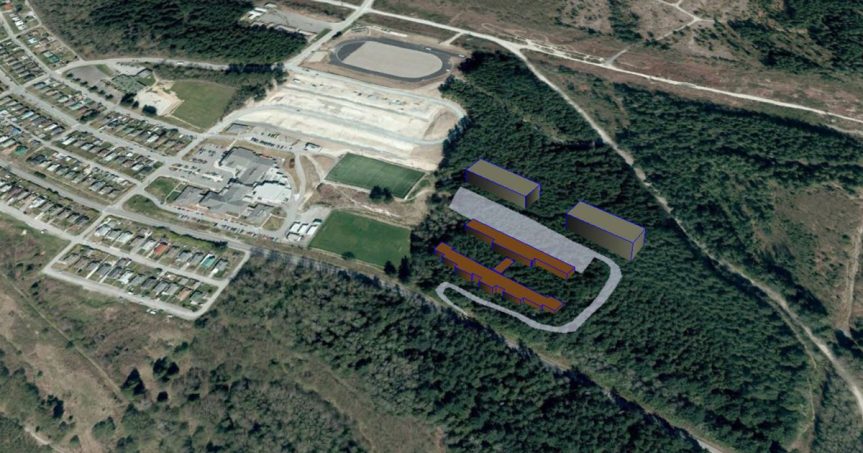
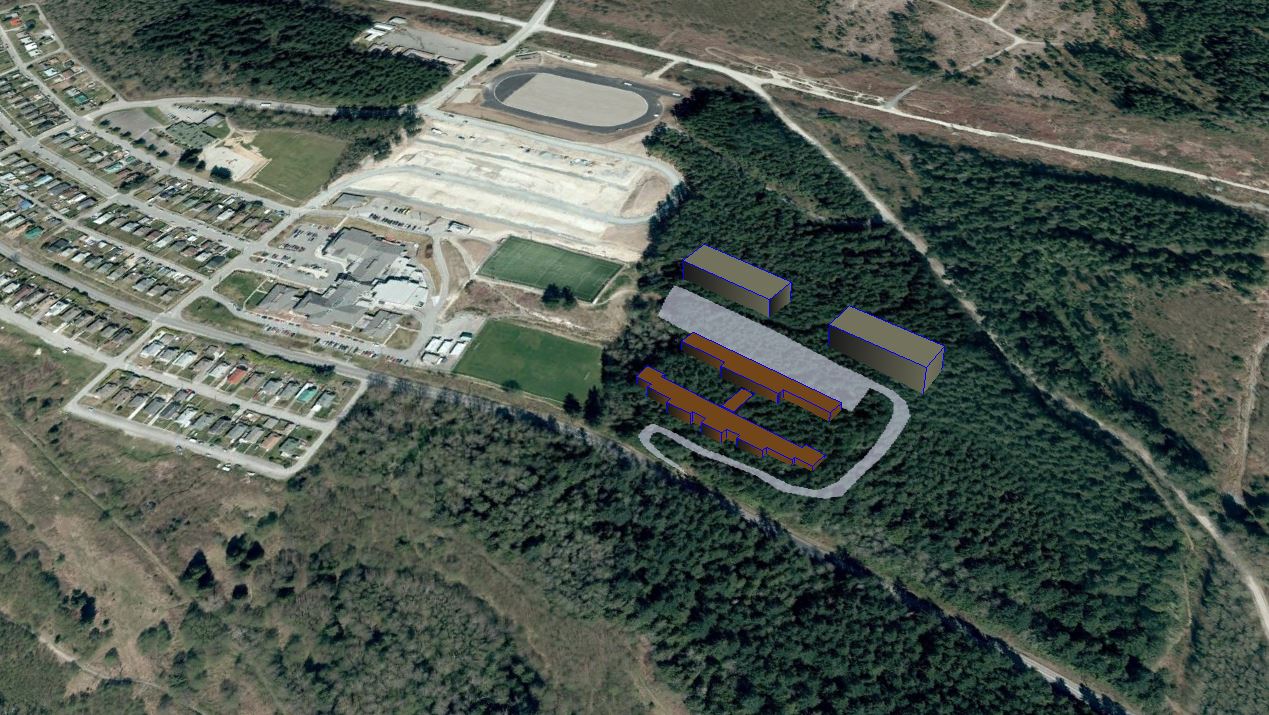
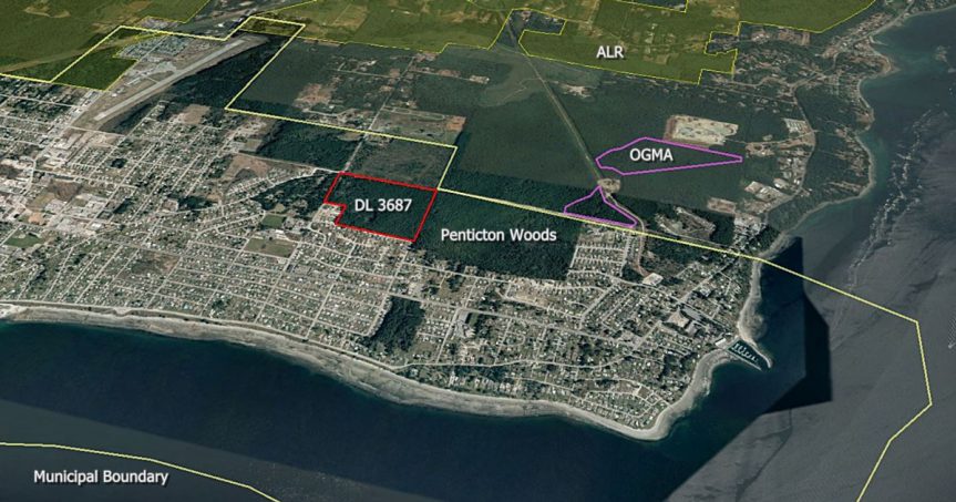
This Google Earth image also shows the municipal boundary, the Agricultural Land Reserve (ALR), and older forests classified as Old Growth Management Areas (OGMA).
Buying the farm

The “incubator farm” idea has been shelved – because “farming groups said they were not in favour“.

I have no opinion about that.  Incubator farms seemingly work really well in some situations.

But a couple of other things caught my eye when I looked again.

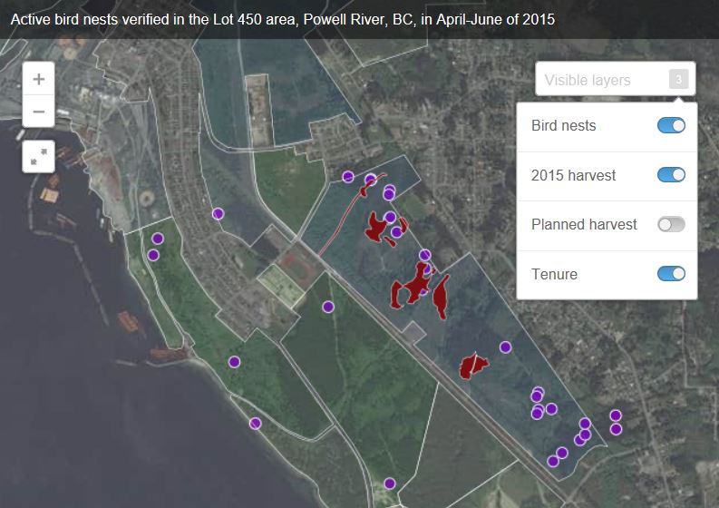
Incubator farm location

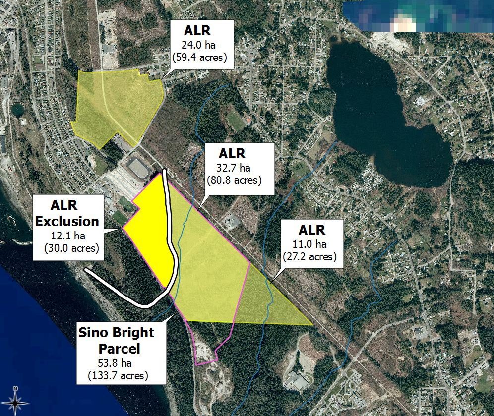
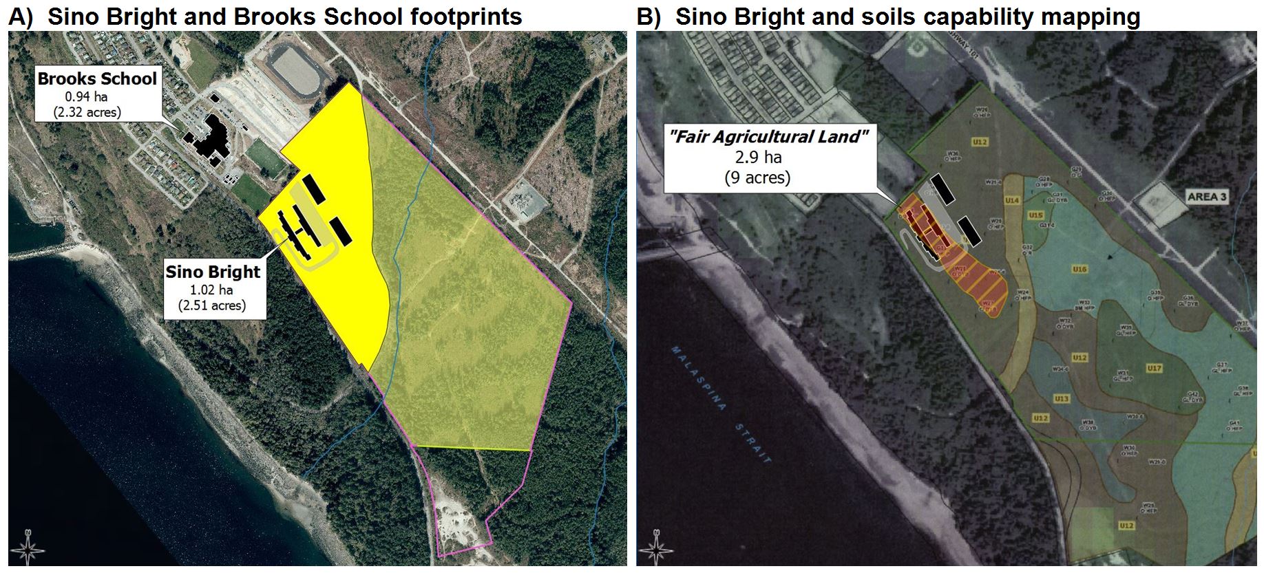
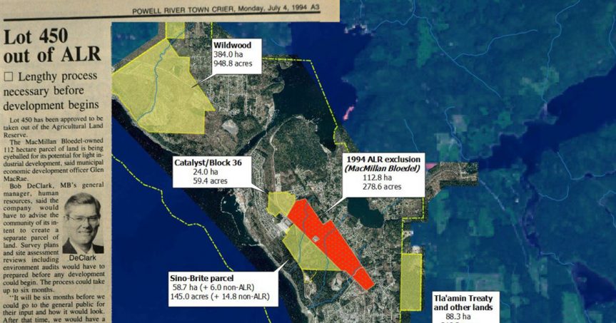
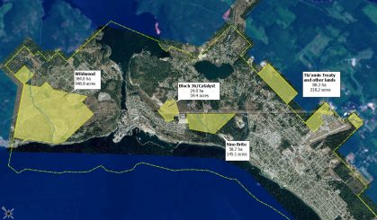
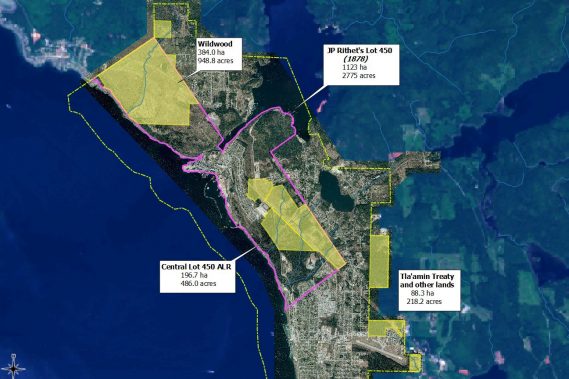
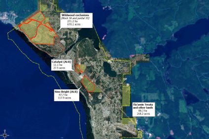
The “New Ground” proposal as crafted by the Powell River Educational Services Society (PRESS) makes no mention of the “Sino-Bright parcel” on Lot 450.  That really surprised me – because according to the public meetings I attended, that’s where it was slated to go. For example, on 6 June the Peak reported that:

“The location of the incubator has yet to be decided, but [Mr.] Randolph said its preferred location is within the residual agricultural reserve land that Sino Bright School BC (SBSBC) intends to purchase from PRSC Land Development, a corporation owned by the city and Tla’amin Nation, if that deal goes through.”

Forest cover within Powell River, BC, as of 20 April 2016
Figure 2: Remaining mature forest within Powell River City limits as of 20 April 2016.
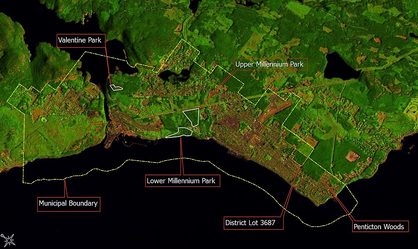
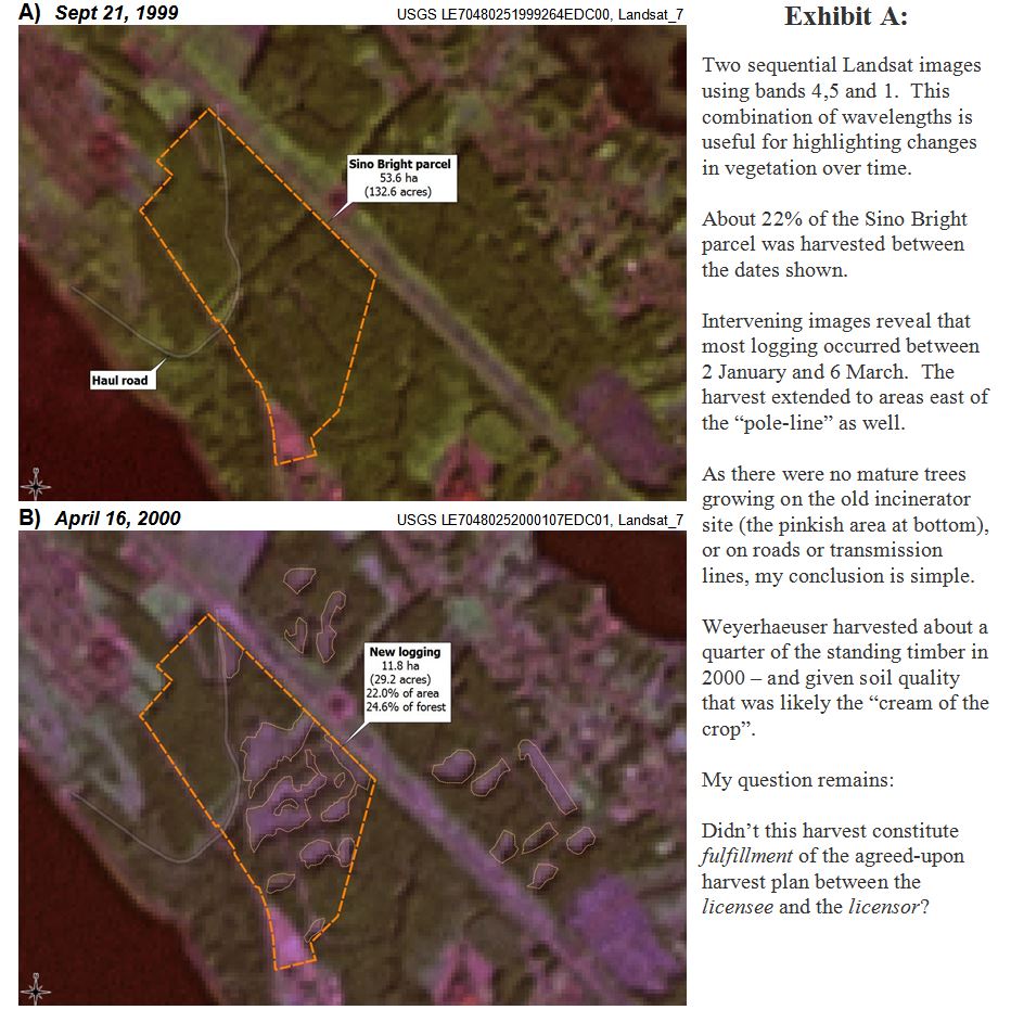
This Landsat 8 image uses bands 7-6-4, making mature forests appear very dark green.
Built-up urban areas and new cutblocks appear reddish-brown, while regenerating forests appear as very light green.

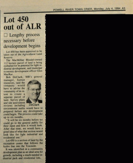
In fact, the New Ground proposal considered only a single area: District Lot 3687.  I didn’t know where that was, so had to look it up.

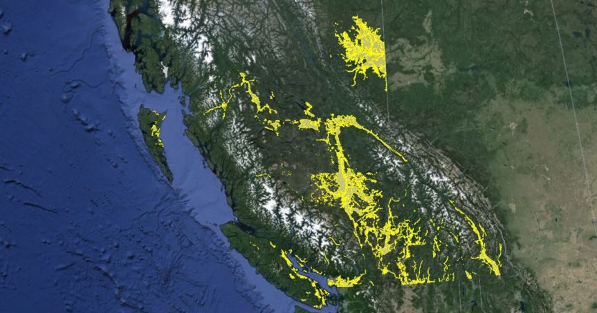
Zooming out at bit (Landsat flies 705 km overhead), we can see that:

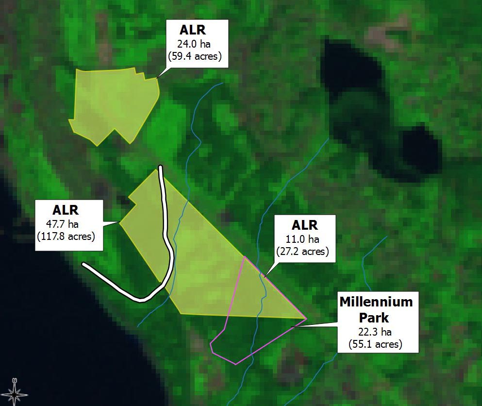
  • DL 3687, combined with adjacent Penticton Woods, is one of 3 large blocks of forest remaining within city limits.
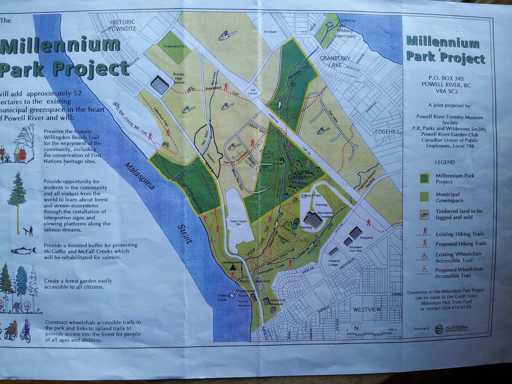
  • Along with Millennium Park, the area is the only substantial chunk of forest owned by the City.
  • These and other lands (the Sino-Bright parcel, and the Valentine/Pole-line PMFL) represent a last chance – to realize the original “garden city” vision of a community surrounded by a “green belt of trees and parkland”.
Andrew Bryant on Lot 450 PMFL, 12 May 2015
I don’t often wear hi-viz when conducting “global inventories of flora and fauna”, but when I do…
it’s always somebody else’s

Other elements of the New Ground proposal deserve mention.  The cost of tree-cutting and stump-removal wouldn’t have been trivial – $240,000 to get 20 acres “into production”.   But I cringed to see that forest described as “vacant land”.

I did like the idea of a “global inventory of flora and fauna using or occupying site and bordering areas”, but that item didn’t merit a line-entry  in the budget.  Some apparently believe that such inventories are easy, or cheap.  They’re not.

In any event, the incubator farm idea is on hold, and I suspect it’s unlikely to re-emerge for the Sino-Bright parcel either.  I don’t mind.  From my perspective, converting healthy forests into marginal cropland is intrinsically a bad idea.

But what still really irks me is this:

Once again a major land redevelopment was contemplated – one that would have involved clearing a large forested area – and that fact wasn’t made part of the public discussion.

Fuel loads, wildfire and biodiversity
Pileated Woodpecker, 20 Dec 2016
Pileated woodpecker at Penticton Woods, 20 Dec 2016.

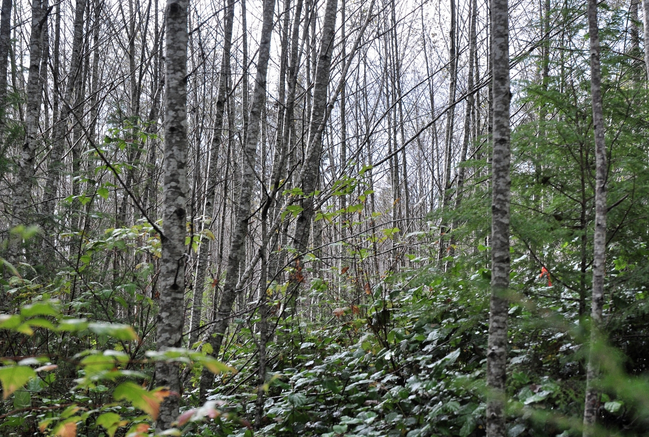
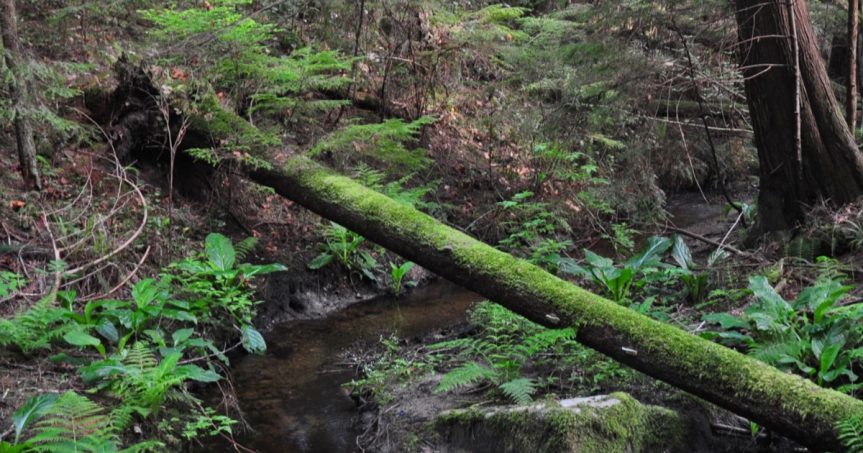
A second issue became apparent during walks in the area for the Christmas Bird Count.  The birds were nice, but mostly I was struck by the evidence of recent brush-clearing.  The impacts were both obvious and extensive.

Time for more research.

It didn’t take long to figure things out.  Back in 2014, the Regional District had enlisted a consulting firm, Blackwell and Associates, to prepare a Community Wildfire Protection Plan.  Said plan, which you can read here, is both thorough and detailed.

In a nutshell, the report sought to map the Regional District in terms of “fuel loads”.  The idea is that the risk of damage to property through wildfire can be minimized if you manage those loads.  Makes sense.  Nobody wants another Kelowna or Fort McMurray disaster in the “wildland-urban-interface”.
Accordingly, one of the recommendations was:

“The Regional District should work with forest operators (e.g., licensees, woodlot operators, private land owners, etc.) to reduce fire risk in their operating areas…”

Things moved quickly, as was reported by various sources on 21 March, 21 Sept and 12 Oct of 2016.  That’s why parts of Penticton Woods and District Lot 3687 look the way they do (see the slide-show at upper right).

Western toad (Bufo boreas)
The Western toad (Bufo boreas) is a “blue-listed” species in B.C. Like most, this species is utterly reliant upon a variety of habitats to satisfy life-history requirements.

That’s also why my recent rambles in the woods made me think long and hard about Pacific Wrens, Wilson’s Warblers, mushrooms, beetles, ants, frogs, salamanders and, yes, toads.

There’s a wealth of scholarly work on the effects of forest understory removal upon low-nesting birds, small mammals and, in particular, amphibians.

One 2004 review of studies from forests in the Pacific Northwest concludes that while more scientific work on the subject is needed;

“Today, the challenge is to maintain biodiversity in western forests in the face of intense political pressures designed to “prevent” catastrophic fires.”

The bottom line

The key issue here, as is often the case, is whether it’s a good idea to make land decisions based on single criteria, or a single report.  Removing “downed and woody debris” is a good prescription for eliminating fire hazard, but will pretty much ruin the habitat for many other species.  Standing snags are dangerous for fallers, but critical for cavity-nesting birds. Incubator farms are great if they help young farmers get into the farming business – and silly if they don’t.

Whew…
….I’m so glad I got that off my chest

I can’t help but occasionally feel like Sisyphus, wondering when or if we will collectively “get it”, and realize that the value of an urban forest is more than just logs to the barge, or fodder for the next brilliant idea about what to do with “vacant land”.

Because…It’s…Not…Vacant…Land

. (period)

Housekeeping matters: more about the ALR

Sino Bright parcel, 9 November 2015
Somewhere on the “Sino Bright parcel”,
9 November 2015
The ALR

Mention the ALR in Powell River and you’ll likely evoke strong reactions – some love it, some see it as an impediment to development, and some see it as yet another great idea mis-managed.

Me?  I’m reminded of Aldo Leopold, who wrote:

There are two spiritual dangers in not owning a farm.  One is the danger of supposing that breakfast comes from the grocery, and the other that heat comes from the furnace.”  

The farm
Madrone Soils Map
Agricultural land capability as mapped by Madrone Environmental Services, with the Sino Bright parcel and proposed ALR exclusion superimposed. Some areas (e.g. the haul road and McGuffie Creek) are not suitable for agriculture at all.
On this map the brownish areas are rated as “poor”, blue-grey areas are rated as “fair”, and dark green and teal-colored areas are “good” (improvable to Class 1 or 2).

To begin: the agricultural potential of the Sino Bright parcel is modest.

Madrone’s 2007 land capability report is thorough and credible.  A portion (40%) of the area contained “good” agricultural soils (i.e., improvable to Class 1 or 2).  The majority (53%) was rated as “fair” or “poor” (improvable to Class 3 or 4).

In short, this is not prime agricultural land.  Especially if you view farming as having to be large-scale, or mechanized, in order to be successful.

That’s nonsense, of course – there are all sorts of ways to successfully farm smaller areas, even in tiny Powell River.

Personally, I suspect that opportunities for mechanized farming were greater on the 112 ha that was excluded from the ALR in 1994 – precisely because it’s flatter.   But I digress. My point is that the Sino Bright parcel is functional agricultural land, for reasons that Aldo Leopold would have fully appreciated – because it’s being used to grow trees.

Well, it’s sort of being used to grow trees.  Here’s where history intervenes, and things get complicated.

Some history
Timber rights on the property were conferred by a sequence of corporate name changes, acquisitions and divestments over time.
In particular, the demise of MacMillan Bloedel Ltd in 1998-99 saw the unusual separation of land ownership and forest ownership.
[UPDATED Sep 2019]
The current landowner (PRSC) acquired the land from Catalyst, who got it from a subdivided MacMillan Bloedel Ltd, descendant of the original Powell River Company of 1911.

However, timber harvest rights have been considered separately since 1998, when MacMillan Bloedel restructured itself.  In this case the flow of timber rights was from MacMillan Bloedel to Weyerhaeuser to Island Timberlands.

For this reason the current (PRSC) or future (Sino Bright) landowner has little control over forests, or the timing and methods of harvesting.  It’s akin to buying a farm without control of the crop.

I recognize that the Land Commission’s mandate is not to evaluate how well landowners have maintained the integrity of agricultural lands or invested in their future potential.   Their job is to a) preserve agricultural land, b) encourage farming on it, and c) encourage local governments to do the same.

The furnace
Exhibit A:  Two sequential Landsat 7 images using 4-5-1 bands.  This band-combination is useful in evaluating vegetation changes over time.  Bottom line?
About 22% of the Sino Bright parcel (and 25% of the standing timber) was logged between the two dates.

Two things caught my eye while exploring this particular land parcel.  Specifically, its agricultural potential has already been degraded.

The first problem stemmed from logging, in this case by MacMillan Bloedel and Weyerhaeuser, in 1999-2000.  The logging itself is not the issue.  I have no problem with thinking about forests as a crop – indeed that’s why we have a “tree-farm license” system in BC.  From my perspective this is a good idea, especially if it encourages the maintenance of forests, forestry workers, and biological diversity.

Sadly, however, in this instance (and in many others in the region), clearcutting and removal of wood was followed by…nothing.  The land was neither replanted nor tended with forestry values in mind.

So instead of a healthy young crop of fir, hemlock and cedar, these areas are now overgrown with red alder and blackberries. When asked their opinion of the harvested patches and what they’d advise doing with them, two foresters who walked with me expressed the same opinion: “mow it down and start afresh”.

State of forest regeneration inside one of the areas harvested in 2000. This photo was taken on 31 October 2015. Click to enlarge.
Forest regeneration in one of the areas harvested in 2000. This image was made on 31 October 2015.

Because I’m an ecologist who understands the value of early successional forests, I don’t think I’d go so far.

But their opinion does underscore my point. Some 16 years after harvest, a substantial portion of the area is not what it could have been.

Or to use Aldo’s words…

…the land is not being used to its full potential, providing for breakfast or the furnace.

The language of the original timber License is quite explicit:

“The Licensor acknowledges that the Licensee has the full right and privilege to harvest and remove the timber growing on the lands as of May 31, 1998.  A harvesting plan is to be reasonably agreed to between between the Licensee and the Licensor.”

The agreement further states that upon termination, the lands and roads will be left “in a condition reasonably acceptable to the Licensor” and that

“Once the timber has been harvested in accordance to the agreed upon harvesting plan and removed by the lands by the Licensee, this license and all rights inferred will terminate.  Any remaining timber not harvested by the Licensee at this time will belong to the Licensor.”

One would assume that the terms of the license were fulfilled – i.e., that there was a harvesting plan “reasonably agreed to” by Pacifica Papers (the Licensor in June 1999) and Weyerhaeuser (who acquired the Licensee MacMillan Bloedel Ltd in November of that year) – prior to any trees coming down.

weyerhaeuser
Weyerhaeuser
The future is growing

So I remain puzzled by the subsequent grant of timber rights by Norske Skog Canada to Weyerhaeuser in June of 2005 – with no mention of the fact that the Licensee had already exercised their rights by cutting 1/4 of the standing timber.  I’m puzzled also that Weyerhaeuser, which advertised itself as the “tree-growing company”, had not replanted the land – or seemingly been asked to do so by the Licensor.

Was the “reasonably agreed to” harvesting plan in 1999 just considered to be incomplete in 2005?

As in “sure, my company can mow your lawn…we’ll do the easy bits now, then come back later to finish up… maybe in five years time…or fifteen years…or whenever we feel like it”.
Really?

I suspect we’ll never see details of the agreed-upon harvest plan.  It was likely just an annotated forest cover map, with some notes about road access.  Some might consider that this is old news, and doesn’t really matter.  I would argue that it very much does matter, because it comes down to a question of what the future may hold for a parcel of land that still contains substantial forest values.

Another problem

The second problem was something that at first I thought was the GIS version of a “typo”. What I’d noticed, after comparing Landsat imagery and ALR maps, was something odd.

Clearing of Timberlane Estates in 2010
Exhibit B: This sequence of images shows forest clearing for the Timberlane Estates subdivision between July of 2009 (A) and July of 2010 (B). More land-clearing (this time for installation of the Timberlane athletic track to the north) occurred shortly thereafter (C).
As can be seen on an image from 2011, the semi-circular loop road at the top of Hemlock Street was constructed on the ALR.

Had a paved municipal road really been constructed on the ALR?   Yes.  Could I be certain of when it was constructed?  Yes.  Was there an application related to it, or a decision made about it?  Well, not that I can find.

Housekeeping matter
This is the “housekeeping matter” referred to in City planning documents when it was belatedly realized that the road was constructed on the ALR.

Construction of the road amounted to an “effective” ALR exclusion size of about 0.8 ha (1.8 acres).

The Powell River Peak again provides essential context (sadly, many of their online archives have disappeared).

One article described the land sale, and a follow-up story provided more details and a map of the planned subdivision.  From these it’s apparent that the road was part of the design from the very start.

These two Powell River Peak articles provide historical context for the road - but seemingly the ALR was forgotten in the process. Click to enlarge.
Exhibit C: Two Powell River Peak articles provide historical context for the road
– but seemingly the ALR was forgotten about in the planning process.
 part of the ALR...
part of the ALR…

At this point it’s impossible to be certain about why or how this happened.  But it did, and it means that in terms of the subdivision for which 8 acres were sold by the PRSC, about 10 acres were actually used to develop it.

Yes, more nibbling away at the ALR – Powell River style.

It is rather a nice road…but somehow I think Aldo would be unimpressed.

Whither Sino Bright? A brief history of the neighborhood

What Sino Bright might look like. This image was created by scanning and georeferencing a map contained in a City planning document, and then creating a 3-D footprint in Google Earth. I have no idea how high the buildings would be, but the "footprint" is certainly "large" when compared to Brooks Secondary School. Click to enlarge.
What Sino Bright might look like.
This image was created by georeferencing a map from a City planning document, and then creating a 3-D footprint in Google Earth.
I have no idea how high the school or dorm buildings would actually be, but the “footprint” is certainly “large” when compared to adjacent Brooks Secondary School.
Another ALR exclusion

As the ALC considers excluding 12.1 hectares (30 acres) from the ALR in order to accommodate Sino Bright school, I thought it might be useful to revisit the history of this and surrounding lands.  

Some may be unaware that the proposed exclusion is part of what used to be a much larger ALR – and that this is not the first time these lands have come up for exclusion.

So far I’ve been unable to find an actual electronic or paper map of the 1975 ALR.  So I had to work backwards, starting with a 2014 map that was available from the ALC.  Then it became a matter of synthesizing information contained in government documents and old newspapers.  Here’s what I’ve learned from the exercise.

The ALR in 1975
1975: The "Green Heart" of Powell River was a contiguous parcel of ALR. - A. Bryant/ImagineLot450
1975: The “Green Heart” of Powell River was once a contiguous parcel of ALR.

At time of designation in 1975, the ALR in central Powell River comprised a single parcel of about 200 hectares.

Landsat images from this period are of low resolution (30 m) by modern standards.  They are, however, sufficient to show absence of large-scale forest harvesting.  The “pole line” is clearly visible, and the “haul road” barely so.

Most of the standing timber was approaching 40-60 years of age, representing 2nd growth after earlier logging and the great fire of 1923.

The 1994 Exclusion
1994: MacMillan Bloedel, with support from City Council, asked for exclusion of 112.75 ha.
1994: MacMillan Bloedel Ltd, with support from City Council, asked for and received exclusion of 112.75 ha from the ALR.

The first major change occurred in 1994, when a private landowner (MacMillan Bloedel Ltd) applied for exclusion of 112.75 hectares.  MacMillan Bloedel was owner of the mill and substantial other properties at the time.

At that time private landowners were allowed to apply for exclusion of their own land, provided they secured the support of local government.

Although ALR staff recommended refusal, the application was endorsed by Powell River City Council, citing “community need”.  The applicant envisioned light industrial and residential development, with a “buffer” between the two along McFall Creek.

Both the maps and decision are worth studying in full.  The letter confirming exclusion is dated 12 May 1994.  Apparently the discussion took some time, and was not without debate.   I note the language of the decision, which states, in part:

“While the Commission is reluctant to grant unconditional approval of the exclusion of these lands, it is confident that planning for the future uses of the property will be such that there will be no need for additional ALR lands to satisfy the growth requirements of the community in the foreseeable future.”

The Yrainucep proposal
Powell River was considered part of the "south coast" panel then. The <i>Yrainucep</i> decision is missing...
Powell River was considered part of the “south coast” then.
The September decision is missing…

The next major event came in 2006 with the strangely-named “Yrainucep” (pecuniary spelled backwards) proposal.   I’ve so far been unable to obtain a copy of either the application or the decision that was released on 24 Sept 2007.

The decision is missing from where I would have expected to find it on the ALC’s otherwise excellent web-based archive of decisions.  However, according to an earlier article in the Powell River Peak (21 June 2007):

“The city has applied to the ALC to remove five parcels containing 245-hectares from the agricultural land reserve in order to create economic development and diversify the tax base.  Madrone Environmental Services Ltd. reported on the land capability for 352-hectares of the property, which it divided into three distinct areas: Area 1, 284-hectares, located north of Powell River in the Wildwood area; Area 2, 13-hectares, located along Cranberry Street and the BC Hydro power line; and Area 3, 55-hectares, located between the Townsite and Westview.”

PR_Peak_Sep_26_2007
Some of the Powell River Peak on-line archives are currently unavailable
click on the picture to read the article.

This ultimately proved to be a “non-event” in terms of the ALR, because the Commission flatly refused the application.  Again according to the Powell River Peak (26 Sept 2007), the Commission remained concerned about a number of issues, including:

  • loss of agricultural land, much of which, with improvements, was considered suitable for agriculture
  • absence of details about the proposed development, or the degree to which that would address community needs
  • lack of an inventory of the land base in Powell River, and
  • that lands excuded from the ALR in 1994 for economic development reasons remained undeveloped.

I’m still trying to clarify some of the details, but note that the application included the Sino Bright parcel presently under consideration.  In any event, Yrainucup did not proceed and nothing happened to the ALR.

UPDATE  [27 Dec 2016]:  The missing ALC decision and relevant maps have now been found – thanks to a careful reader and diligent record-keeper – Thank you!

The 2009 ALR subdivision of Lot “A”
The 2009 application to subdivide the ALR was a critical step in the creation of Millennium Park. Click to enlatge.
The 2009 application to subdivide the ALR was a critical step in the creation of Upper Millennium Park.

Fast forward to 2009, which saw another ALR application – one that few probably noticed, and fewer still would have considered important.  This was the application to sub-divide the southern portion of the remaining ALR.

The intent in this case was to permit the legal acquisition of what is now known as Upper Millennium Park.  

Presumably a subdivided ALR  was also an essential step towards making lands to the west of the park available for sale or consideration of other developments.

Millennium Park proposal_map
A 1998 concept map for Millennium Park includes a green corridor along McFall Creek from Willingdon Beach to Cranberry Lake.
In retrospect, it might have been easier to keep this treasure had the entire area been maintained as ALR.

The long-held dream to create Millennium Park, born of a few people in the late 1990s, was finalized in early 2015 with the purchase of trees from Island Timberlands (who still own, I hasten to add, harvest rights for standing timber on the rest of the ALR).

Note that Island Timberlands also owns, lock, stock and barrel, the former ALR to the northeast that is now Private Managed Forest Land (PMFL)…

…and that Millennium Park wound up being just a tad smaller than the dreamers dreamed.

The Sino Bright proposal
The 12 ha (30 acres) under consideration for exclusion are highlighted, and comprise about 22% of the Sino Bright Parcel. Click to enlarge.
The 12 ha (30 acres) under consideration for exclusion are highlighted, and comprise about 22% of the Sino Bright Parcel.

At last we come to the present (2016) application for exclusion.   Here we see the ALR that remains in Millennium Park, and also the adjacent “Sino Bright” land parcel of 54 ha (134 acres), some of which is outside the ALR.

The 12.1 ha (30 acres) proposed for exclusion are highlighted in bright yellow.

Details of the proposed Sino Bright private school remain sketchy, although some relevant planning documents are available here and here.  The job-creation prospects are both enticing – and similarly devoid of detail.

I scanned and geo-referenced a paper map of the proposed Sino Bright school footprint. It’s not small.  Excluding roads and parking lots, the building area is similar to that of the adjacent Brooks Secondary School.  It also occupies a large fraction of the proposed exclusion area.

I did the same for the Madrone Environmental Services soil capability mapping done in 2007 in support of the Yrainucep proposal.  The full report can be found here.  Together the two maps offer some additional perspective about the impacts, both visual and otherwise.

Sino Bright and Brooks Secondary School relative footprint in Powell River
In terms of size, the two schools will have approximately the same footprint (map A), but clearly the size of the proposed Sino Bright school would essentially “fill” the entirety of the 12 ha ALR exclusion.
Map B shows soil characteristics as mapped by Madrone in 2007 – the 2.9 ha area of “fair agricultural land” is highlighted (hatched). One can easily appreciate how leaving that area as ALR (as City staff recommended on 17 May 2016) would have made things, well, difficult for the developer…
One big question

For me, one major question remains unaddressed, although it has been been asked repeatedly, for example here and here.

“Why does Sino Bright have to be built there? ” 

It’s not my place to 2nd guess the engineers or urban planners, but I can think of at least a couple of other possible locations, one of which is the former ALR owned by Island Timberlands, the other of which is owned by the same landowner (PRSC) that owns the Sino Bright parcel…

Click to enlarge

Personally, I think the old golf course would provide better views…

Food for thought: Powell River’s ALR in context

Map of the ALR in 2014
Source? I downloaded a shapefile from the ALC, converted it to a kml, viewed that in Google Earth, and took a screenshot.  Pretty, isn’t it?
A bold idea

British Columbia’s Agricultural Land Reserve (ALR) is both vast and beautiful when viewed on a single map.  I wanted to learn more about how our local ALR fits into the larger picture…

Mostly I was interested in learning what changed… and how well we’re doing in terms of protecting agricultural potential.

I imagined this to be straightforward – start with a map from 1975, overlay a current map, and measure the differences.  Simple, right?

The problem of baseline data
These annual reports are freely available on-line. Only a few of them contain data at the Regional District level.
Annual reports are available from 2009. Alas, few of them contain comparable, district-level data.

Alas, I couldn’t find a digital map of the 1975 ALR.  A second problem stemmed from Regional District changes over time. There were 27 Regional Districts at the time of ALR designation, and 28 today: Comox-Strathcona was split to become Comox Regional District and Strathcona Regional District in 2008.

That complicates the accounting, even if annual reports were always produced – which they sometimes weren’t.  Welcome to the unhappy world of searching government archives in hopes of finding consistently-collected or reported data.

In practice it proved difficult to obtain usable data, particularly concerning the early years of the ALR.  Others have experienced similar issues; for example there’s some revealing correspondence provided by the City of Burnaby here.

The problem of changing methods
Three planimeters - digital, Amsler and Prytz. These instruments measure the area of a two dimensional region of arbitrary shape. - Simona Fišnarová Wikipedia Commons
Planimeters (in this case a digital, an Amsler and a Prytz) are tools for measuring the area of a two-dimensional shape on a map.
– S. Fišnarová (Wikipedia)

Initially, ALR boundaries were hand-drawn on paper maps, and the areas of land parcels were measured with tools like “dot grids” or planimeters that I’m sadly old enough to remember using.  These provided “reasonably” accurate estimates at the time – but times have changed.

The ALR has now been mapped using modern GIS methods – but for several reasons the new numbers don’t exactly match the old ones.  They’re close – but not perfectly so.  This adds to the difficulty of monitoring changes, because it’s easy to lose track of a few hectares here and there given changing methods and the sheer size of the ALR.

The problem of scale
Regional District ALR sizes as measured by GIS and "old-school" methods. The correlation is high (Pearson r = 0.997). Powell River Regional District is shown in green. Click to see at full size.
Figure 1: Regional District ALR sizes as measured by GIS and “old-school” methods. The correlation is high (Pearson r = 0.997).
Powell River Regional District is shown in green.
Click to enlarge.

Regional ALR parcels vary greatly in size.  Having very large, and very small, land areas makes it difficult to see where “we” are on a normal graph.  Consider the two graphs at left, which show exactly the same data and exactly the same correlation between “old-school” and newer measurements.  They look different – but they’re not.

Plotted on a “normal” scale (A), Powell River disappears into the messy pile of data on the extreme lower left.  On a log-transformed scale (B), it’s easier to see that we’re at the low end of the data distribution – and that’s my point.

Powell River started with a tiny ALR in 1975 (141 km²).

Contrast this with regions such as Peace River (14,534 km²), Cariboo (9,251 km²) or Thompson-Nicola (5,687 km²) .  Only four districts started with a smaller ALR than we did (Mount Waddington, Central Coast, Sunshine Coast and Alberni-Clayoquot).  Scale really matters: ours and the other 4 districts could have lost all our ALR, or doubled it, and we would still be a blip on the provincial tally (46,208 km²).

But to keep it simple – remember that my purpose was to compare what we had in 1975 with what we have left – the answer is that it’s not simple.

Individual ALR parcels increased or shrunk over time.  Parcels were added (inclusions) or deleted (exclusions). Permitted “agricultural uses” were re-classified (think golf courses).  Regional Districts changed, human populations changed, and reporting procedures changed.  And all of these things changed at various times, at various rates, and across various parts of the province.

Eventually I decided to explore the ALR on a per region and a per capita basis, using data compiled from the ALC, BC Stats and Wikipedia.

Results
Figure 2: ALR changes from the time of establishment (1975-76) through March of 2015. Plot A shows % net change in area for each Regional District, while B reflects changes in population size as well. Data for Powell River are shown in green. Click to enlarge.
Figure 2: ALR changes from the time of establishment (1975-76) through March of 2015. Plot A shows % net change in area for each Regional District, while B reflects changing population sizes as well. Data for Powell River are shown in green.
Click to enlarge.

On a regional basis, a few northern areas showed large increases in ALR.  Notable were Bulkley-Nechako (+25%), Mount Waddington (+16%) and Northern Rockies (+7%).  Most regions suffered losses, with the largest occurring in Columbia-Shuswap (-19%), Powell River (-31%) and Sunshine Coast (-37%).

On a per capita basis the data were similar, and together these plots present a fairly coherent picture of the 40-year history of the ALR.  Regions like Central Coast, Mount Waddington, and Skeena-Queen Charlottes experienced declining populations and substantial ALR inclusions; the result was an increase in per capita ALR since 1975.  Most other regions show significant declines.

Using the per capita index, Powell River, with a nearly stable population, sits roughly in the middle, showing a 35% loss.  Sunshine Coast, with its exploding human population and high ALR exclusion rate, fared the worst, losing 73% of its per capita ALR.

Conclusions
Figure 3: Per capita ALR by Regional District. Data are initial (1975; open bars) and recent (2015, solid bars) ALR sizes, expressed as hectares per person. Powell River District is shown in green. Click to enlarge.
Figure 3: Per capita ALR by Regional District. Data are initial (1975; open bars) and recent (2015, solid bars) ALR sizes, expressed as hectares per person.
Data for Powell River are shown in green.
Click to enlarge.

There are still parts of British Columbia where the ALR is of sufficient size to allow for 5 or even 10 hectares of agricultural land for every man, woman and child.  Conversely, most regions do not.

The 2015 Provincial average is 0.96 hectares of ALR per person (4,620,858 ha of ALR divided by 4,625,497 people).  But as we’ve seen, the distribution of that land is far from uniform.

In Powell River, we’ve gone from an below-average value of 0.72 ha/person in 1975 to 0.49 ha/person in 2015.

I’m not much of a farmer myself…but when I look at the the data, and the trends in the data, and the absolute necessity to have places to grow food…I just can’t support the further exclusion of ALR lands – for any reason.   Can you?

Call it food for thought.
Or thought for food.

Riparian follow-up: Good News!

Determination from the Managed Forest Council (MFC), dated July 2015
This “determination” from the Managed Forest Council (MFC) is dated July 2015 – Click to read it on the MFC website.
Following up is good

In the course of searching for something else, I came across this determination published by the Managed Forest Council (MFC).

I knew some of the background already.

Background
McGuffie Creek, 18 May 2015
McGuffie Creek, 18 May 2015 – Click to enlarge

The (now defunct) Pebble in the Pond Environmental Society had asked me to provide my impressions on the status of riparian areas in Lot 450 (on 16 May).

This I did (on 19 May).  You can read it here.

My impressions were that the riparian areas surrounding McGuffie, McFall and Wys Creek remained mostly intact.  By that time Pebble in the Pond had announced that they’d retained a lawyer, contacted the MFC, and that a “file had been opened”.

The investigative process

What I didn’t realize at the time was that a legal complaint had already been drafted and submitted  (on 14 May).  That letter stated, in part, that:

“Our client has further concerns that riparian values and fish habitat are also being unlawfully impacted, and our client has been advised by members of the local community that logging equipment has been crossing through streams without sufficient safeguards for water quality and fish habitat during harvesting”

This was (is?) news to me.

The result

In any event I’m greatly encouraged to report that MFC took the matter seriously.   Thus another registered professional biologist (RPBio) was employed to visit the site (on 15 June) to examine the aforementioned riparian areas and report his findings.  Based on that report, MFC determined that Island Timberlands had not contravened the Private Managed Forest Land Act or regulations.

We should all sleep better – though nary a tree was saved, the process worked.

Thank you Pebble !!! – Click to enlarge

The Hamilton & Associates report was thorough, professional, and in my estimation, accurate.   This fact notwithstanding,  I wonder what the cumulative costs of this “investigative process” were?  

I suspect they were substantial, including legal fees paid for via public donations, and administrative fees and a professional report commissioned by, and ultimately paid for, by MFC and PMFL landowners.

In retrospect… I think my effort had nicer photos…but he had way better maps…


Updated: 23 July 2016

Nibbling away at the ALR: Powell River style

1994-M&B-exclusion_B
“Lot 450 out of ALR”
Powell River Town Crier, 4 Jul 1994
– Click to enlarge
Math matters

Arithmetic took me back to the archives.  There I was surprised to find, among a pile of dusty newspapers, something that contradicted much of what I thought I knew about Lot 450.

As a relative newcomer to the community I’ve come to love, learning the following just…well, it just breaks my heart.

What arithmetic?   The issue was that I couldn’t make sense of a 2006 Powell River Peak story that mentioned, in passing, that 112 hectares had been excluded from the Agricultural Land Reserve (ALR) “10 years ago”…

Since it’s pretty hard to hide 112 hectares in an area the size of Powell River, I first imagined that the article must have been referring to the “old golf course” or the “lower section of Block 55”.  But those land parcels just weren’t the right size, so my numbers weren’t adding up.   So where on earth was it?

Turns out that it referred to that entire section of land where I spent so much time in May.  The very place where a group of brave souls faced down a feller-buncher.  The spot where some Powell Riverites gained national attention over the idea that maintaining some urban forest around might be a wise thing to do.  Simply put, what many know as “Lot 450” used to be part of the ALR.

This is old news, of course, but what happened in 1994 and later may provide some new context with which to understand current plans, which will have repercussions for lands that were initially cataloged to preserve farmland.

As they say, the devil is in the details…

A brief history of the ALR in Powell River

(Click on any image to start a full-screen slide show)

Those bird nests again

Clicking on this image will open a new browser tab, where you can explore the various bird species that nested there.
You can also see the harvested cutblocks in 2015, Island Timberlands’ harvest plan for the area, and see who owns which land parcels.
Enjoy!

Here’s another look at those bird nests confirmed during the 2015 breeding season.

In total, n=32 nests and 14 species, including my personal favorite, that lovely Brown Creeper on 16 May…I’d never seen a nest of that species before!

Although I found most of the nests, records were also supplied by Guy Monty, Robert Colasanto and Christopher Heffley – Thank You!

Be the raven…and stay watchful...