If a tree falls in the forest: will the Supreme Court hear it?

Upper and lower Millennium Park, the ALR and proposed ALR exclusion, and an alternative site location for Sino Bright School in Powell River, BC
Plan C:
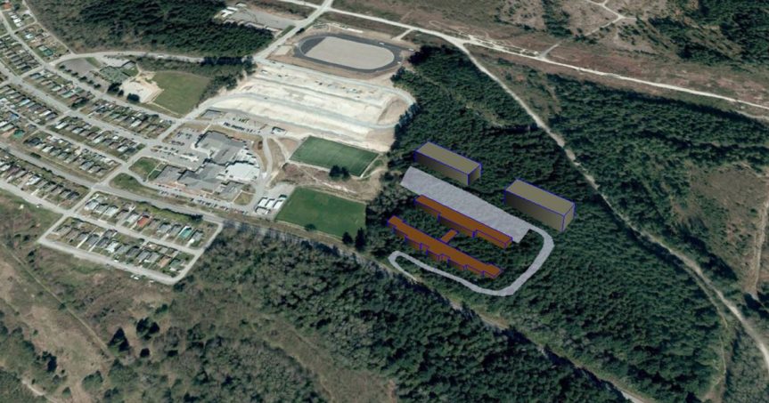
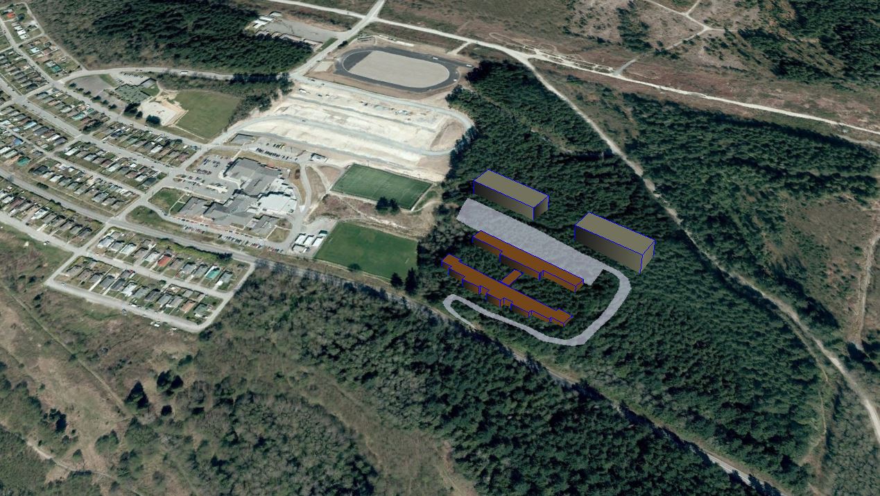
With ALR exclusion off the table, maybe it’s time to re-think what the “Green Heart of Powell River” could be – if the trees don’t have to come down.
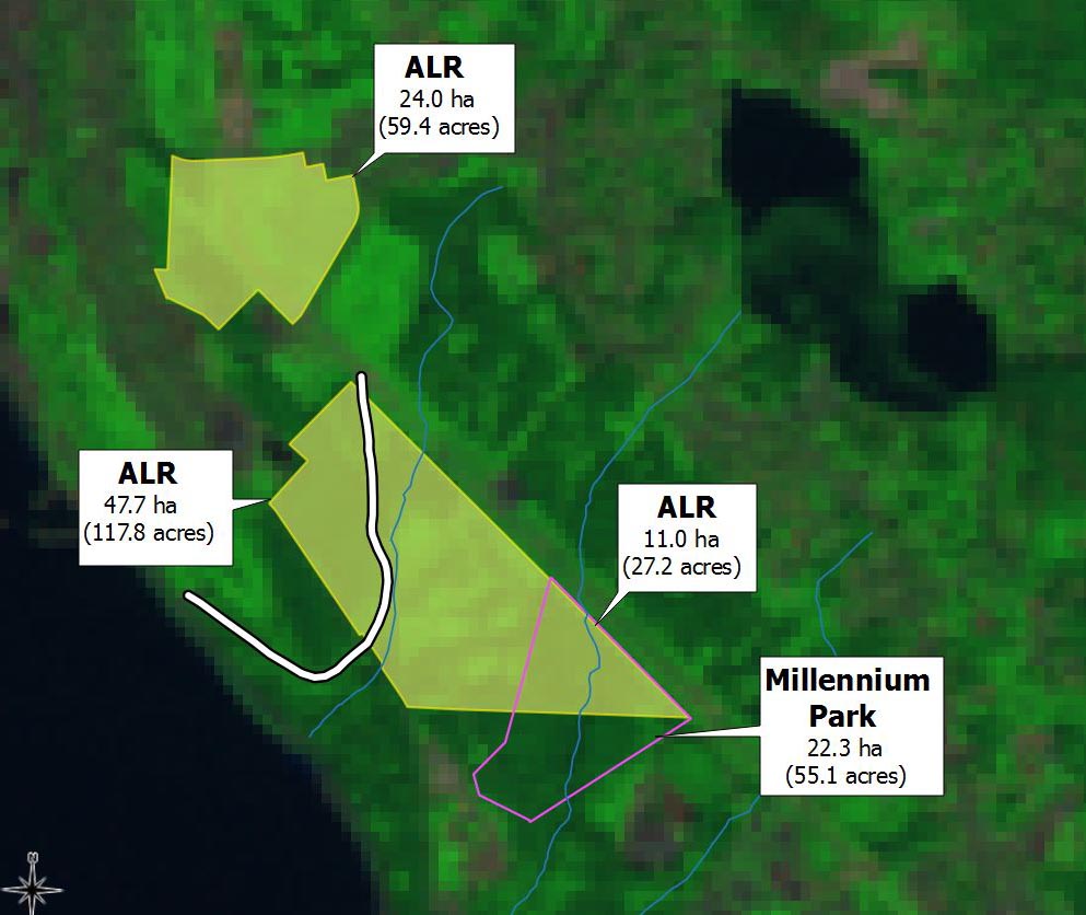
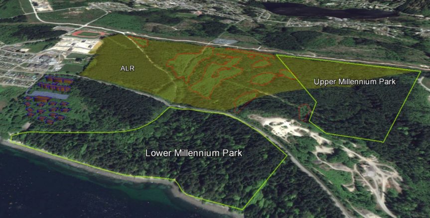
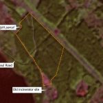
This image shows the ALR surrounded by upper and lower Millenium Park – it also shows the areas harvested in 1999-2000 – and what Sino Bright could look like if re-positioned on the old golf course.
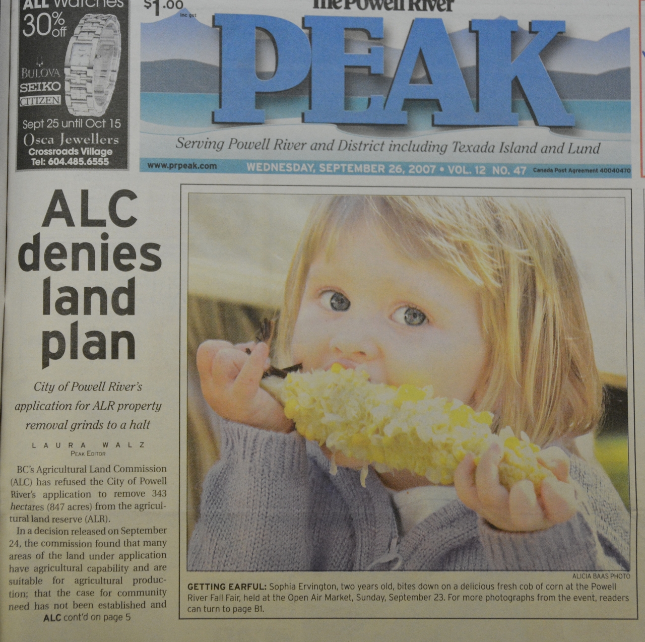
State of denial

The recent Land Commission decision to deny exclusion of ALR lands came as a shock to some – which puzzles me.

Given events in 1994 and 2006, Powell River has a history of asking for ALR exclusions on the basis of “community need” – and then not providing a very compelling case for them.

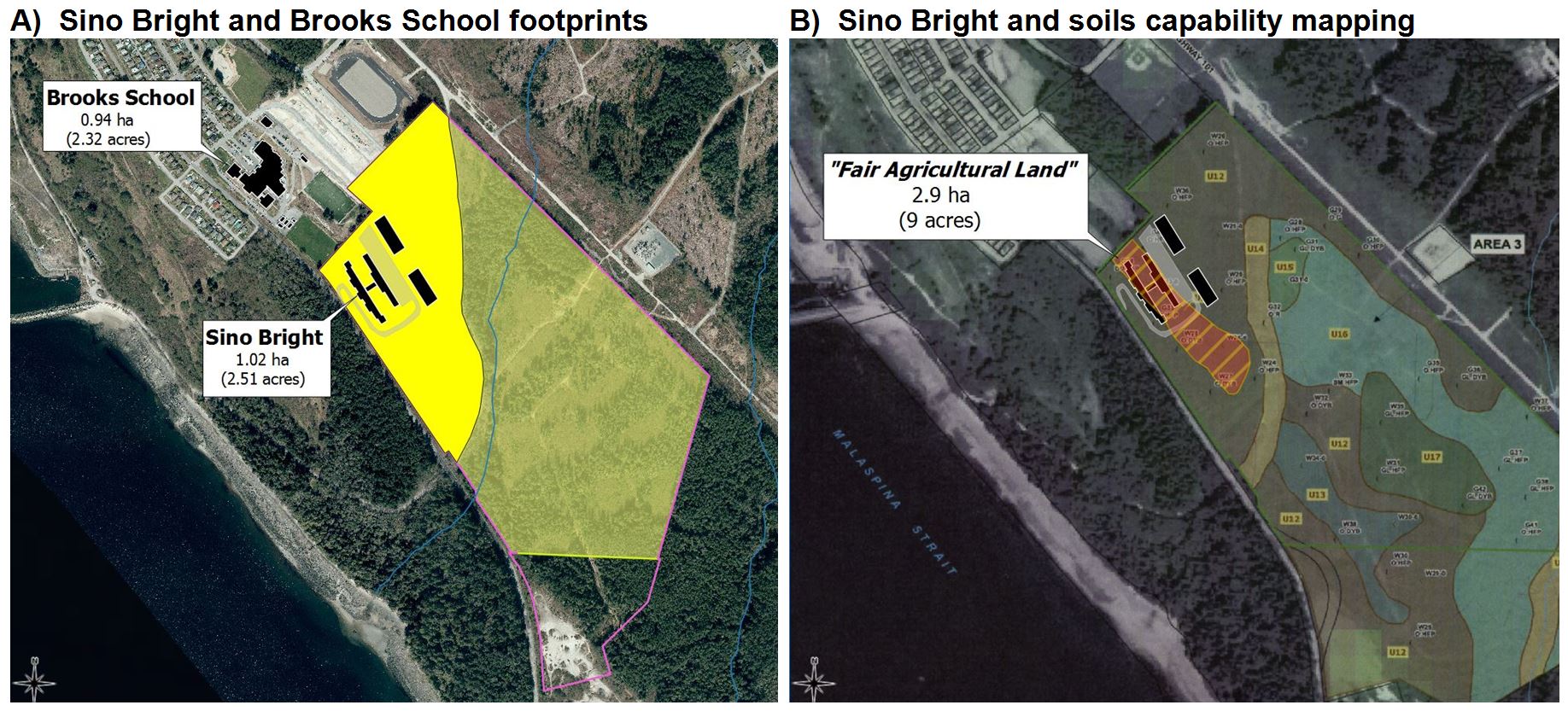
The ALC decision is available here.  Briefly, it says a) there is some modest agricultural potential on the land, and b) there was no detailed analysis of other potential locations.

In essence the ALC asked, as others have (e.g., herehere and here); why did Sino Bright School have to be built on the ALR?   Their decision is admirably brief:

“The Panel finds that the Proposal would be more appropriately located on lands outside of the ALR.”

I agree.  And I really, really hope that the PRSC, VIU, School District 47 and Sino Bright were far-sighted enough to have envisioned the need for a Plan B.  

Background

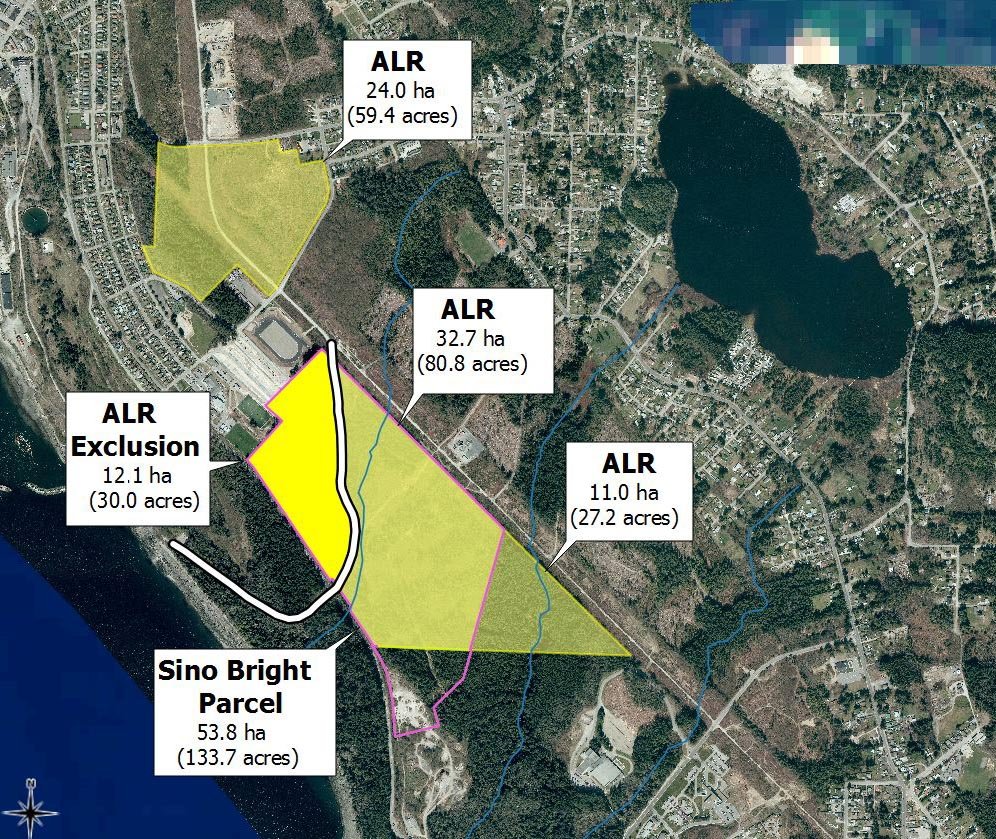
Elsewhere I’ve described the history of what I call the “Sino Bright parcel” and other PRSC lands, much of which was shaped by MacMillan Bloedel’s subdivision in 1998.

mb_1998_licence_signed_small
Geoffrey Mynett signed on behalf of the Licensor and the Licensee.
Click to read the full licence.

To recap, one branch became the pulp and paper division (558654 BC Ltd), while the other kept the M&B name and forestry operations.  Thus we have the amusing case of one person signing both sides of a contract, in which the Licensor (558654 BC Ltd) granted one-time rights to the Licensee (M&B) to “harvest and remove the timber growing on the land as of May 31st 1998.”

There’s nothing untoward about this – it was a simple corporate restructuring.  Nor is it odd that the licence was renewed a year later, when 558654 BC Ltd became Pacifica Papers.  What was, I think, utterly unexpected was the takeover of M&B by Weyerhaeuser, four months later, in November of 1999.

Here’s where it became interesting to me, in light of the wording of the 1998 licence and the 1999 affirmation that:

“Licence terminates upon harvesting of timber in accordance with harvesting agreement between Pacifica and MB”

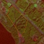
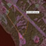
The satellite imagery is unambiguous.  Logging of the Sino Bright parcel and adjacent properties began in October of 1999 (under MacMillan Bloedel) and continued until April of 2000 (under Weyerhaeuser).  About 25% of the trees were harvested.  From the best soils on the property.

Man stands for Lot 450 Powell River Peak, December 16, 1999
Man stands for Lot 450
Powell River Peak, Dec 16, 1999

The takeover didn’t change much on the ground.  It was the same loggers, the same trucks and chainsaws, that started and finished the job.  There was no real difference – it was the same forestry operation – only with a different corporate address.

As always, the Peak dutifully recorded these changes. There wasn’t much public outcry – but there was some.

The legal question

In August of 2016 I was encouraged to contact one Andrew Gage, a lawyer with West Coast Environmental Law.  As is my nature, I supplied him with far more data that he probably expected.  In turn he agreed to study the issue and form an opinion.  Further, he agreed to write a letter on my behalf if he thought the situation had legal merit.

Letter from West Coast Environmental Law to the PRSC and shareholders, 14 September 2016
Click to read the full document.

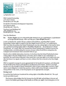
Here’s Mr. Gage’s letter.  It was mailed on 14 Sept 2016 along with Exhibit Awhich illustrates the same cut-blocks shown above.

According to the 1998 licence, there should have been a “mutually agreed-to harvest plan” prior to any trees coming down.  Trees came down, so I think it’s reasonable to assume that there was some kind of a harvest plan.

The licence also states: “Any remaining timber not harvested by the Licensee at this time will belong to the Licensor.

I think the key issue raised here is: at what point are “partly-exercised” rights conferred by a licence considered to be “expired”?

The opportunity

Andrew Gage’s central point is that a “proceeding brought by petition” under BC Supreme Court Civil Rules could be a relatively inexpensive means of clarifying the question of “who owns the trees?”  And that PRSC Limited Partnership Ltd, and by extension its two shareholders, have a moral, legal and fiduciary responsibility to do so.

His letter even outlined the necessary “next-steps”.

BC Supreme Court Civil Rule 2-1(2)(c) applies when

the sole or principal question at issue is alleged to be one of construction of an enactment, will, deed, oral or written contract or other document;

BC Supreme Court Civil Rule 2-1(2)(g) relates to land and seeks

(ii) a declaration that settles the priority between interests or charges,

The ramifications

I confess to having become excited by the possibilities that the foregoing raised.

  • What if the ALC denied the application for exclusion, and the Sino Bright land sale fell through as a result?
  • What if a Supreme Court Judge were to rule that yes, the evidence is that one-time harvest rights were exercised, and rights to the remaining timber reverted to the Licensor, and are therefore not held by Island Timberlands?
  • What if it turned out that a substantial chunk of forested land – bordered by upper and lower Millennium Parks, a soon-to-be rehabilitated incinerator site, and Brooks Secondary School – didn’t automatically have to be clearcut?

Once upon a time I did a radio interview in which I described myself, and this website, as being “unimaginative”.   Well, here goes.  I’m calling it Plan C.   Whaddya think?

Accordingly, in September I followed up with a few phone calls – followed by individual emails to the Mayor and City Councilors in October.

I’m still waiting to hear back…

Whither Sino Bright? A brief history of the neighborhood

What Sino Bright might look like. This image was created by scanning and georeferencing a map contained in a City planning document, and then creating a 3-D footprint in Google Earth. I have no idea how high the buildings would be, but the "footprint" is certainly "large" when compared to Brooks Secondary School. Click to enlarge.
What Sino Bright might look like.
This image was created by georeferencing a map from a City planning document, and then creating a 3-D footprint in Google Earth.
I have no idea how high the school or dorm buildings would actually be, but the “footprint” is certainly “large” when compared to adjacent Brooks Secondary School.
Another ALR exclusion

As the ALC considers excluding 12.1 hectares (30 acres) from the ALR in order to accommodate Sino Bright school, I thought it might be useful to revisit the history of this and surrounding lands.  

Some may be unaware that the proposed exclusion is part of what used to be a much larger ALR – and that this is not the first time these lands have come up for exclusion.

So far I’ve been unable to find an actual electronic or paper map of the 1975 ALR.  So I had to work backwards, starting with a 2014 map that was available from the ALC.  Then it became a matter of synthesizing information contained in government documents and old newspapers.  Here’s what I’ve learned from the exercise.

The ALR in 1975
1975: The "Green Heart" of Powell River was a contiguous parcel of ALR. - A. Bryant/ImagineLot450
1975: The “Green Heart” of Powell River was once a contiguous parcel of ALR.

At time of designation in 1975, the ALR in central Powell River comprised a single parcel of about 200 hectares.

Landsat images from this period are of low resolution (30 m) by modern standards.  They are, however, sufficient to show absence of large-scale forest harvesting.  The “pole line” is clearly visible, and the “haul road” barely so.

Most of the standing timber was approaching 40-60 years of age, representing 2nd growth after earlier logging and the great fire of 1923.

The 1994 Exclusion
1994: MacMillan Bloedel, with support from City Council, asked for exclusion of 112.75 ha.
1994: MacMillan Bloedel Ltd, with support from City Council, asked for and received exclusion of 112.75 ha from the ALR.

The first major change occurred in 1994, when a private landowner (MacMillan Bloedel Ltd) applied for exclusion of 112.75 hectares.  MacMillan Bloedel was owner of the mill and substantial other properties at the time.

At that time private landowners were allowed to apply for exclusion of their own land, provided they secured the support of local government.

Although ALR staff recommended refusal, the application was endorsed by Powell River City Council, citing “community need”.  The applicant envisioned light industrial and residential development, with a “buffer” between the two along McFall Creek.

Both the maps and decision are worth studying in full.  The letter confirming exclusion is dated 12 May 1994.  Apparently the discussion took some time, and was not without debate.   I note the language of the decision, which states, in part:

“While the Commission is reluctant to grant unconditional approval of the exclusion of these lands, it is confident that planning for the future uses of the property will be such that there will be no need for additional ALR lands to satisfy the growth requirements of the community in the foreseeable future.”

The Yrainucep proposal
Powell River was considered part of the "south coast" panel then. The <i>Yrainucep</i> decision is missing...
Powell River was considered part of the “south coast” then.
The September decision is missing…

The next major event came in 2006 with the strangely-named “Yrainucep” (pecuniary spelled backwards) proposal.   I’ve so far been unable to obtain a copy of either the application or the decision that was released on 24 Sept 2007.

The decision is missing from where I would have expected to find it on the ALC’s otherwise excellent web-based archive of decisions.  However, according to an earlier article in the Powell River Peak (21 June 2007):

“The city has applied to the ALC to remove five parcels containing 245-hectares from the agricultural land reserve in order to create economic development and diversify the tax base.  Madrone Environmental Services Ltd. reported on the land capability for 352-hectares of the property, which it divided into three distinct areas: Area 1, 284-hectares, located north of Powell River in the Wildwood area; Area 2, 13-hectares, located along Cranberry Street and the BC Hydro power line; and Area 3, 55-hectares, located between the Townsite and Westview.”

PR_Peak_Sep_26_2007
Some of the Powell River Peak on-line archives are currently unavailable
click on the picture to read the article.

This ultimately proved to be a “non-event” in terms of the ALR, because the Commission flatly refused the application.  Again according to the Powell River Peak (26 Sept 2007), the Commission remained concerned about a number of issues, including:

  • loss of agricultural land, much of which, with improvements, was considered suitable for agriculture
  • absence of details about the proposed development, or the degree to which that would address community needs
  • lack of an inventory of the land base in Powell River, and
  • that lands excuded from the ALR in 1994 for economic development reasons remained undeveloped.

I’m still trying to clarify some of the details, but note that the application included the Sino Bright parcel presently under consideration.  In any event, Yrainucup did not proceed and nothing happened to the ALR.

UPDATE  [27 Dec 2016]:  The missing ALC decision and relevant maps have now been found – thanks to a careful reader and diligent record-keeper – Thank you!

The 2009 ALR subdivision of Lot “A”
The 2009 application to subdivide the ALR was a critical step in the creation of Millennium Park. Click to enlatge.
The 2009 application to subdivide the ALR was a critical step in the creation of Upper Millennium Park.

Fast forward to 2009, which saw another ALR application – one that few probably noticed, and fewer still would have considered important.  This was the application to sub-divide the southern portion of the remaining ALR.

The intent in this case was to permit the legal acquisition of what is now known as Upper Millennium Park.  

Presumably a subdivided ALR  was also an essential step towards making lands to the west of the park available for sale or consideration of other developments.

Millennium Park proposal_map
A 1998 concept map for Millennium Park includes a green corridor along McFall Creek from Willingdon Beach to Cranberry Lake.
In retrospect, it might have been easier to keep this treasure had the entire area been maintained as ALR.

The long-held dream to create Millennium Park, born of a few people in the late 1990s, was finalized in early 2015 with the purchase of trees from Island Timberlands (who still own, I hasten to add, harvest rights for standing timber on the rest of the ALR).

Note that Island Timberlands also owns, lock, stock and barrel, the former ALR to the northeast that is now Private Managed Forest Land (PMFL)…

…and that Millennium Park wound up being just a tad smaller than the dreamers dreamed.

The Sino Bright proposal
The 12 ha (30 acres) under consideration for exclusion are highlighted, and comprise about 22% of the Sino Bright Parcel. Click to enlarge.
The 12 ha (30 acres) under consideration for exclusion are highlighted, and comprise about 22% of the Sino Bright Parcel.

At last we come to the present (2016) application for exclusion.   Here we see the ALR that remains in Millennium Park, and also the adjacent “Sino Bright” land parcel of 54 ha (134 acres), some of which is outside the ALR.

The 12.1 ha (30 acres) proposed for exclusion are highlighted in bright yellow.

Details of the proposed Sino Bright private school remain sketchy, although some relevant planning documents are available here and here.  The job-creation prospects are both enticing – and similarly devoid of detail.

I scanned and geo-referenced a paper map of the proposed Sino Bright school footprint. It’s not small.  Excluding roads and parking lots, the building area is similar to that of the adjacent Brooks Secondary School.  It also occupies a large fraction of the proposed exclusion area.

I did the same for the Madrone Environmental Services soil capability mapping done in 2007 in support of the Yrainucep proposal.  The full report can be found here.  Together the two maps offer some additional perspective about the impacts, both visual and otherwise.

Sino Bright and Brooks Secondary School relative footprint in Powell River
In terms of size, the two schools will have approximately the same footprint (map A), but clearly the size of the proposed Sino Bright school would essentially “fill” the entirety of the 12 ha ALR exclusion.
Map B shows soil characteristics as mapped by Madrone in 2007 – the 2.9 ha area of “fair agricultural land” is highlighted (hatched). One can easily appreciate how leaving that area as ALR (as City staff recommended on 17 May 2016) would have made things, well, difficult for the developer…
One big question

For me, one major question remains unaddressed, although it has been been asked repeatedly, for example here and here.

“Why does Sino Bright have to be built there? ” 

It’s not my place to 2nd guess the engineers or urban planners, but I can think of at least a couple of other possible locations, one of which is the former ALR owned by Island Timberlands, the other of which is owned by the same landowner (PRSC) that owns the Sino Bright parcel…

Click to enlarge

Personally, I think the old golf course would provide better views…